Mundell & Associates, Inc.

Consulting Professionals for the Earth and the Environment

  • Careers
  • Hablamos Español
call us at (317) 630-9060
110 S. Downey Ave, Indianapolis, IN 46219 | Fax: (317) 630-9065
  •  
  • Company
    • About Us
    • Our Staff
    • Mission and Vision
    • Social Mission
    • Hablamos Español
    • Careers
    • Contact
  • Services
  • Industry Solutions
  • Portfolio
  • News
Discuss your projectall news
You are here: Home / Consulting Services / Geophysical Services / Geophysical Techniques / Electromagnetic Conductivity Mapping
service logo

Electromagnetic Conductivity Mapping

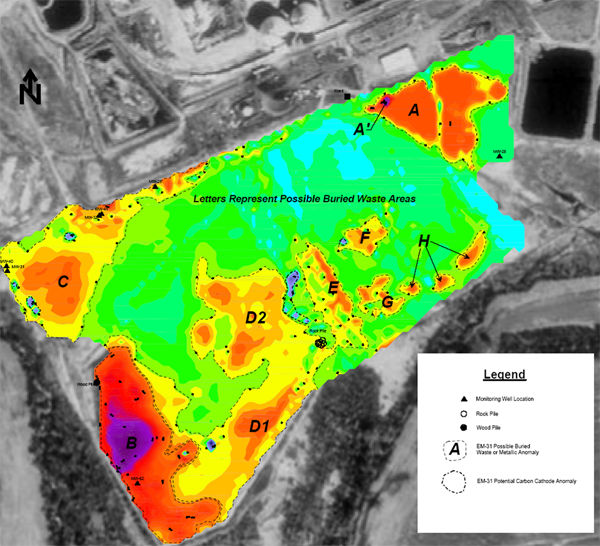
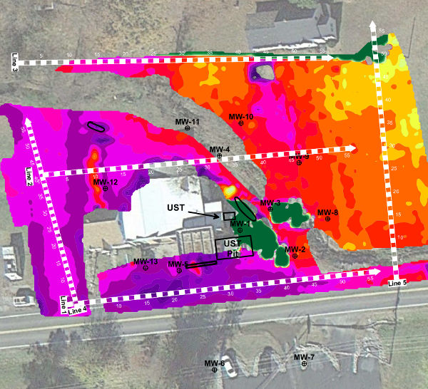
Are you baffled by how one small chemical source area impacted your entire site? Are you looking to locate the extents of impacted soils across your site? Could your site contain areas of buried metallic and non‑metallic waste? A terrain conductivity survey using EM conductivity meters may an option.

We utilize a variety of EM conductivity meters (Geonics EM31, EM34, EM38 and a Geophex GEM-2) to map out shallow variations in geology, locate preferential pathways involved in chemical source migration, and delineate zones of buried fill. These conductivity meters have penetration depths ranging from 5 to 100 feet below ground surface and can be hand carried across smaller, gridded survey areas, or towed on a non-metallic cart behind a utility vehicle for larger sites using a differentially corrected GPS (sub-meter accuracy) to control the data positioning.

From a small parking lot, to entire landfills, we can delineate the subsurface anomalies of your site.

Electromagnetic Conductivity Applications

  • Mapping Variations in Soil Type
  • Preferential Pathway Locating
  • Shallow Karst Mapping
  • Buried Waste Delineation
  • Chemical Source and Extent mapping
EM31 Mapping
EM Conductivity Meter in Action
GEM-2 Electrical Resistivity Map

Discuss your projectall news

  • Consulting Services
    • Investigation & Remediation
    • Litigation Support
    • Environmental Management
    • Water Resource Evaluation
    • Geophysical Services
      • Environmental Applications
      • Engineering and Construction
      • Natural Resources
      • Archaeological Studies
      • Geophysical Techniques
        • Electromagnetic Metal Detection
        • Ground Penetrating Radar (GPR)
        • Electromagnetic Conductivity Mapping
        • Electrical Resistivity
        • Seismic Methods
        • Magnetic Methods
        • Borehole Logging
        • Microgravity

News

Regional Levee Project Presented at AEG Annual Meeting during Dams and Levees Symposium

October 7, 2022in Company News

New IDEM Recycling and Waste Diversion Grants Announced

July 8, 2022in Company News

Karst, Cake, and Indiana Geology

April 22, 2022in Science and Environment

Mundell & Associates Featured on International News Program

November 30, 2021in Company News

Our Affiliations

- Midwestern States Environmental Consultants Association
- Environmental & Engineering Geophysical Society
- Professional Geologists of Indiana, Inc.
- National Ground Water Association
- American Societies of Chemical / Civil Engineers Engineers without Borders
- Association of Environmental and Engineering Geologists
- Indiana Association for Environmental Professionals
- Geological Society of American
- Indiana Circular Economy Initiative
- Economy of Communion
- Indiana Recycling Coalition

.....and more more affiliations

Be Inspired

Loading...
Download calendarGet full calendar ICAL· Google Calendar

Help Protect Your Nearby Wetland

No matter where you live, chances are there is a wetland nearby. (Wetlands go by many names: estuaries, bogs, swamps, marshes, playa lakes, and more). Keep lawns and driveways free of pet waste, fertilizers and motor oil. These pollutants can wash into storm drains and eventually reach a wetland.

Source: Mother Earth News

.....see all tips more tips

Copyright © 2023 · Mundell & Associates, Inc. · 110 S. Downey Avenue, Indianapolis, IN 46219 · (317) 630-9060 · Privacy Policy · Terms of Use · Sitemap