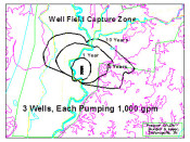
As part of its wellhead protection program, an Indiana water company wanted to determine the 1, 5 and 10-year time-of-travel delineation zones for its water supply under current and future pumping rates. …..Read More »
Portfolio
Key: Case Histories (![]() ), Publications (
), Publications (![]() ), and Presentations (
), and Presentations (![]() )
)
Vapor Intrusion Concern Mitigated, Monitored for Effectiveness
Mundell was hired to review reports documenting VOC groundwater impacts migrating from an industrial facility on to our client’s residential and commercial property in Indianapolis……Read More »
DA Lubricant Company
Mundell was retained by a partnering consulting firm at a bulk oil facility were multiple spills had occured. The task was to assess the potential exposures that could result from leaving the residual groundwater impacts in place……Read More »
Air Data Spatial Analysis at Chlorinated Solvent Impacted Site in Northwestern Indiana
Manufacturing processes at an industrial site generated hazardous wastes including multiple volatile and semivolatile organic chemicals (VOCs and SVOCs), heavy metals, and petroleum-related compounds. Nearby residents filed a class action lawsuit against the new property owner seeking damages for diminished property values and abatement of contamination alleged to have migrated from the Site to soil and groundwater beneath homes in a geographically-designated class area. Mundell was retained by a midwestern law firm on behalf of the property owner to render opinions regarding the work activities at the site. …..Read More »
Groundwater Flow and Contaminant Transport Models Used to Assess Risk for Potential Impacted Groundwater Receptors
Mundell used 2D analytic element code GFLOW to generate a composite regional and site specific groundwater flow model beneath a contaminated auto dealership. Using the results of the flow modeling as a basis, chemical transport modeling using the computer code MT3D was performed to evaluate the effects of dispersion, contaminant retardation and decay on the potential downgradient chemical concentrations resulting from on-site releases……Read More »
- « Previous Page
- 1
- …
- 57
- 58
- 59
- 60
- 61
- …
- 64
- Next Page »


