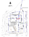
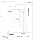
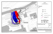
Mundell performed a multi-technique geophysical survey at an active industrial facility, to locate potential sources and migration pathways of a liquid phase hydrocarbon (LPH) seep detected in an adjacent river. Electromagnetic metal detection (EMD) and ground penetrating radar (GPR) were used to detect an unknown UST and tank pit, EM conductivity mapping was used to delineate the extent of impacted soils, and 2-D resistivity and seismic refraction were used to locate migratory pathways to the river……Read More »
Portfolio
Mundell & Associates is a small consulting company with large-company credentials and significant experience with some of the most challenging and diverse environmental concerns.
Our project portfolio (which includes case histories, publications, and presentations) covers the world and includes time sensitive investigations as well as long term remediation and monitoring. Clients benefit from a cross disciplinary approach to problem solving and depend on our abilities to communicate complex scientific and engineering principles.
Examination of Concrete Bridge Beams with GPR
Mundell was contacted by a state regulatory agency to test and confirm that the bridge beams of a new interstate bridge complied with design specifications, prior to the pouring of the bridge deck. Mundell performed a GPR survey of two random beams in order to verify the spacing of reinforcement and the placement of the pre-stressed (PS) cables. Mundell’s data satisfactorily convinced the regulatory agency of the proper construction of the bridge’s support features, allowing the construction process to continue in a timely manner and the bridge to be completed on time……Read More »
Evaluation of Complex Petroleum Migratory Pathway
A former gas station was acting as the source of a complex petroleum plume, which had migrating off-site. Whereas 70 soil borings could not delineate the migration pathways off-site, an EM 31 terrain conductivity survey was able to detect the presence of old field drainage tiles, which were actively transporting the petroleum across and off of the site……Read More »
Drain Mapping At An Active Industrial Facility
Mundell was contacted to map out a drain system at a local industrial facility, which was believed to be acting as a conduit for perchloroethylene (PCE) releases. Mundell used electromagnetic line tracing in conjunction with ground penetrating radar (GPR) profiling to accurately map the drains, allowing for the acute placement of investigative soil borings……Read More »
Bedrock Mapping for Petroleum Remediation Project
In conjunction with ongoing investigation and remediation activities, Mundell used a series of seismic refraction profiles to map the bedrock topography across a site in Ohio. While the bedrock valley discovered by Mundell had been acting as the leading transport mechanism of contamination off site, it was later used as a “recovery trench” in the remediation process……Read More »