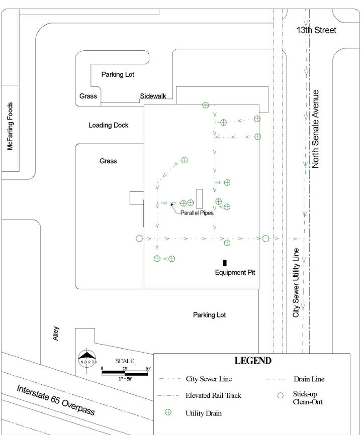
Mundell & Associates, Inc.

Consulting Professionals for the Earth and the Environment

  • Careers
  • Contact
  • Español
call us at (317) 630-9060
110 S. Downey Ave, Indianapolis, IN 46219 | Fax: (317) 630-9065
  •  
  • Company
    • About Us
    • Our Staff
    • Mission and Vision
    • Social Mission
    • Hablamos Español
    • Careers
    • Contact
  • Services
  • Industry Solutions
  • Portfolio
  • News
Discuss your projectall news
You are here: Home / Portfolio / Drain Mapping At An Active Industrial Facility

Drain Mapping At An Active Industrial Facility

portfolio typeCase Historiespdf iconDownload this as PDFPosted on June 22, 2012

Summary map (EM and GPR techniques)

A summary map developed based on geophysical investigation (EM and GPR techniques) to map drain lines at the active industrial facility.

Challenge

Mundell was contacted to map out a drain system at a local industrial facility. The facility had been the site of remedial activities associated with the release of perchloroethylene (PCE), and it was believed that the drain lines were acting as conduits for the contamination, which was leaking through the joints connecting the lines.

Action

To map the drain system, Mundell used electromagnetic line tracing in conjunction with ground penetrating radar (GPR) profiling. The line tracing was performed using a Radiodetection Model RD400PXL-2 receiver and a BendiSonde sonde transmitter. The sonde was fastened to a 100-foot metal sewer snake and advanced through each surface drain location. This allowed for mapping of the pipes within an lateral accuracy of 1 foot and a vertical accuracy of 3 inches. Sections where the electromagnetic line tracing could not be used (areas with pipe bends that have sharp curve radii as small as 4 inches) were characterized using GPR mapping. GPR profiles were collected using a Sensors and Software Noggin Plus System equipped with a Smart Cart and shielded 1000 megahertz antennae.

Result

By using the two aforementioned techniques, the site drain system was accurately mapped, allowing for the acute placement of investigative soil borings.

more information Learn about our related services (Geophysics) and industry solutions (Industrial and Auto)

Similar Portfolio Items

  • Groundwater Resource Assessment: Long-Term Sustainability
  • Dam Rehabilitation Guided by Geophysical Characterization
  • Bedrock Mapping Along Combined Sewer Overflow Storage Alignment

Discuss your projectall news

Portfolio

Case Histories (130)
Presentations (155)
Publications (60)
all news View full portfolio

Latest News

  • John Mundell receives Purdue University’s prestigious Civil Engineering Alumni Achievement Award April 14, 2026
  • Merry Christmas and Happy New Year from Mundell! December 19, 2025
  • John Mundell reflects on the legacy of Pope Francis and his concern for our common home May 27, 2025

Join our mailing list

News

John Mundell receives Purdue University’s prestigious Civil Engineering Alumni Achievement Award

April 14, 2026in Company News

Merry Christmas and Happy New Year from Mundell!

December 19, 2025in Company News

John Mundell reflects on the legacy of Pope Francis and his concern for our common home

May 27, 2025in Community Involvement

Using IndianaMap and web-based GIS to protect drinking water

December 3, 2024in Company News

Our Affiliations

- Midwestern States Environmental Consultants Association
- Environmental & Engineering Geophysical Society
- Professional Geologists of Indiana, Inc.
- National Groundwater Association
- American Societies of Chemical / Civil Engineers
- Association of Environmental and Engineering Geologists
- Indiana Association for Environmental Professionals
- Geological Society of America
- Indiana Geographic Information Council
- Economy of Communion

.....and more more affiliations

Be Inspired

  • Saturday, April 18, 2026
    Free Entrance to National Parks (National Park Opening Weekend)

    National Parks by state

Download calendarGet full calendar ICAL· Google Calendar

Download a Map for Your Next Outdoor Adventure

Reading maps is fun and can tell you a lot about your local environment. The U.S. Geological Survey has been producing detailed topographic maps for more than 125 years. Many are free to download through the USGS Map Store.

Source: Download Maps

.....see all tips more tips

Copyright © 2026 · Mundell & Associates, Inc. · 110 S. Downey Avenue, Indianapolis, IN 46219 · (317) 630-9060 · Privacy Policy · Terms of Use · Sitemap