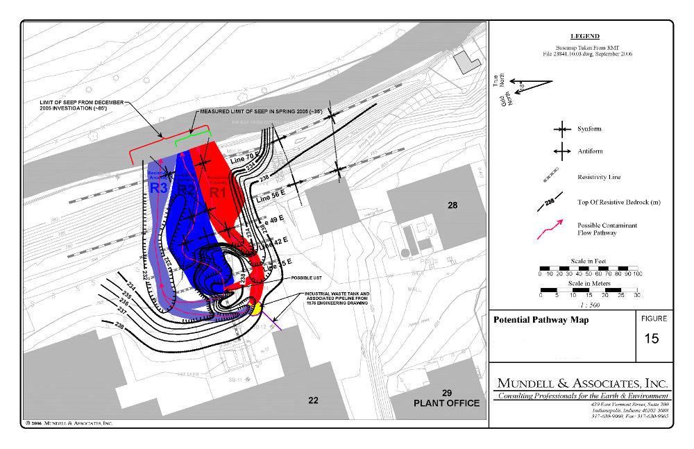
Mundell & Associates, Inc.

Consulting Professionals for the Earth and the Environment

  • Careers
  • Contact
  • Español
call us at (317) 630-9060
110 S. Downey Ave, Indianapolis, IN 46219 | Fax: (317) 630-9065
  •  
  • Company
    • About Us
    • Our Staff
    • Mission and Vision
    • Social Mission
    • Hablamos Español
    • Careers
    • Contact
  • Services
  • Industry Solutions
  • Portfolio
  • News
Discuss your projectall news
You are here: Home / Portfolio / Geophysical Methods Used to Locate Contaminant Flow Pathways

Geophysical Methods Used to Locate Contaminant Flow Pathways

portfolio typeCase Historiespdf iconDownload this as PDFPosted on June 22, 2012

A summary map showing the flow pathways for petroleum impacts based on a multi-technique geophysical survey including 2D resistivity, seismic refraction, and terrain conductivity.

Challenge

Recently, an environmental consultant observed a liquid phase hydrocarbon (LPH) seep on the bank of a creek bordering an active industrial facility near State College, Pennsylvania. A UST had been located in an area of the site adjacent to the seep, but it had been removed several years prior. The consultant asked Mundell to perform a detailed geophysical survey of the site to locate any additional sources of contamination, and to map out the pathways those sources were using to transmit free product to the creek.

Action

Mundell selected electromagnetic metal detection (EMD), ground penetrating radar (GPR), and electromagnetic conductivity mapping to search for unknown source areas across the site. Additionally, two-dimensional resistivity and seismic refraction were used to examine the bedrock for topographic depressions, valleys, or fracture zones.

Results

By using the EMD and GPR techniques, Mundell was able to locate the previous tank pit, and a previously unkown UST. The conductivity results indicated where shallow soils were impacted, including the previous tank pit location. Finally, the resistivity and seismic data showed where bedrock features were transporting the LPH to the creek. The client was then able to use this data to accurately install their remediation system and clean up the site.

more information Learn about our related services (Environmental Applications)

Similar Portfolio Items

  • Multimethod Geophysical Characterization of Fault Systems for Environmental Planning
  • Geophysical and Environmental Investigation Synthesis to Delineate Dual BTEX and MTBE Plume Migration via Preferential Channels
  • Former Salt Storage Site: Geophysical and Environmental Investigation to Delineate a Chloride Plume Impacting Public Drinking Water Supply Wells

Discuss your projectall news

Portfolio

Case Histories (130)
Presentations (155)
Publications (60)
all news View full portfolio

Latest News

  • John Mundell reflects on the legacy of Pope Francis and his concern for our common home May 27, 2025
  • Progress and Challenges for the Future of Indiana Water Resources January 28, 2025
  • Merry Christmas and Happy New Year from Mundell! December 23, 2024

Join our mailing list

News

John Mundell reflects on the legacy of Pope Francis and his concern for our common home

May 27, 2025in Community Involvement

Merry Christmas and Happy New Year from Mundell!

December 23, 2024in Company News

Using IndianaMap and web-based GIS to protect drinking water

December 3, 2024in Company News

Emissions Reporting and Air Dispersion Modeling Allows Tracking of Indy’s Air Pollutants

July 30, 2024in Science and Environment

Our Affiliations

- Midwestern States Environmental Consultants Association
- Environmental & Engineering Geophysical Society
- Professional Geologists of Indiana, Inc.
- National Groundwater Association
- American Societies of Chemical / Civil Engineers
- Association of Environmental and Engineering Geologists
- Indiana Association for Environmental Professionals
- Geological Society of America
- Indiana Geographic Information Council
- Economy of Communion

.....and more more affiliations

Be Inspired

  • Monday, June 16, 2025
    National Pollinator Week

    Polinator Partnership website

Download calendarGet full calendar ICAL· Google Calendar

Reduce Erosion and Preserve Topsoil

Land degradation has increased around the world as our human activities pollute or degrade the quality of soil, affecting not only food production but the overall ecosystems. What can we do locally to preserve our soil?

  • Rotate the crops you grow in your garden.
  • Use local mulch, especially in bare stops to help plants ground and prevent water runoff.
  • Plant large plants such as trees and hedges to reduce wind speed.
  • Minimize soil compaction by create permanent walkways and encouraging people to stay on them.
.....see all tips more tips

Copyright © 2025 · Mundell & Associates, Inc. · 110 S. Downey Avenue, Indianapolis, IN 46219 · (317) 630-9060 · Privacy Policy · Terms of Use · Sitemap