

Challenge
Chloride impacted groundwater was detected in public supply wells downgradient from a former salt storage area in southwest Ohio. The Ohio Environmental Protection Agency (OEPA) requested an investigation to determine 1) the footprint of soil impacts exceeding 1,000 mg/kg, which could act as a continuing source of groundwater impacts above the SMCL of 250 mg/L and 2) whether groundwater migration or surface runoff had impacted surface water in a nearby creek.
Action
Mundell implemented an iterative strategy of subsurface environmental investigation and geophysical conductivity and resistivity surveys to characterize the source area soil impacts and the dissolved chloride groundwater plume. Surface water was also sampled at multiple locations within the adjacent creek. Mundell scientists performed electrical conductivity surveys in the area of the former salt storage pads to identify areas of likely subsurface salt impacts. Initial subsurface soil and groundwater grab samples confirmed the areas of elevated chloride concentrations corresponding to the conductivity survey.
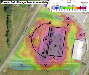
Conductivity Map of Chloride Plume Site
Mundell used the initial soil and groundwater results to identify ideal placement and orientation of three 2D resistivity lines perpendicular to the plume. Mundell geophysicists provided resistivity results identifying depth to bedrock, the surface of which is believed to act as a conduit for dissolved chloride transport. Resistivity results identified zones of peak conductivity, theoretically corresponding to peak chloride concentrations. Based on the 2D resistivity survey results, groundwater grab samples were then obtained at multiple locations and depths along the core and edges of the plume. Sample results confirmed peak concentrations and determined permanent well locations for plume monitoring.
Results
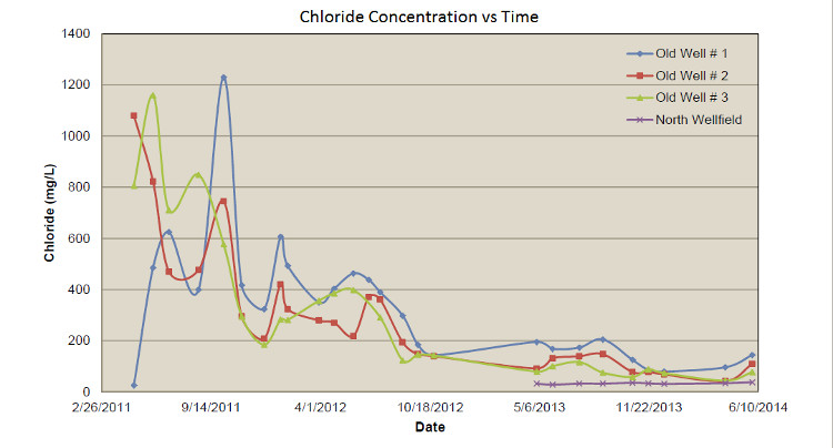
Mundell successfully delineated down-gradient groundwater impacts both vertically and laterally. Sampling of the monitoring well network will provide information on attenuation of chloride concentrations over time and also with distance from the source area. The detailed and accurate delineation will inform the selection of a remedial strategy and allow decision makers including; our clients, the municipality and the OEPA to estimate a future date that the former public supply wells may be brought back into production.
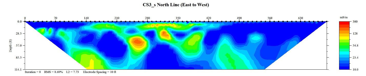
Resistivity Figure of Chloride Plume