Mundell & Associates, Inc.

Consulting Professionals for the Earth and the Environment

  • Careers
  • Contact
  • Español
call us at (317) 630-9060
110 S. Downey Ave, Indianapolis, IN 46219 | Fax: (317) 630-9065
  •  
  • Company
    • About Us
    • Our Staff
    • Mission and Vision
    • Social Mission
    • Hablamos Español
    • Careers
    • Contact
  • Services
  • Industry Solutions
  • Portfolio
  • News
Discuss your projectall news
You are here: Home / Portfolio / Evaluation of Complex Petroleum Migratory Pathway

Evaluation of Complex Petroleum Migratory Pathway

portfolio typeCase Historiespdf iconDownload this as PDFPosted on June 22, 2012

Migration pathways using EM-31 terrain conductivity data.

Map showing the migration pathways located using EM-31 terrain conductivity data.

Challenge

A regional petroleum retailer closed a facility that had been in continuous operation since the 1970’s. Subsequent investigation by Mundell revealed that both soil and groundwater beneath the site were significantly impacted with petroleum hydrocarbons. A limited amount of separate-phase hydrocarbons were present on the groundwater surface in two areas. A dissolved benzene plume had migrated off-site. Given the location of the fuel delivery system at the site and the local geology/topography, it was unclear how petroleum had migrated over such a large area of the site. Definition of the migratory pathway was essential before effective corrective action could be implemented. Because of the presence of separate-phase hydrocarbons and the off-site migration of impacted groundwater, the Indiana Department of Environmental Management (IDEM) ranked the site as a ‘high priority’ requiring soil and groundwater remediation.

Action

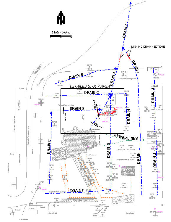
Mundell effectively used electromagnetic conductivity (EM-31 and EM-39), 2-dimensional electrical resistivity and ground penetrating radar to reveal the sources of contaminant movement and to map out the contaminant transport network. This network consisted of narrow, interconnected pea gravel-filled drainage trenches crosscut by utility trenches. Pinpointing of the trench locations and routes, critical to placement of boring locations and to the understanding of the flow network, was accomplished by using a Sensors and Software Noggin 250 ground penetrating radar system. An additional potential benefit to the EM-31 survey was the possible correlation of electrical conductivity with the degradation of petroleum hydrocarbons, consistent with similar recent findings by others.

Results

By accurately locating the drainage trenches, Mundell was able to accurately assess the total petroleum impact at the site with precisely positioned soil borings. Boring results indicated that a large portion of the petroleum hydrocarbons in the unsaturated soil were associated with the drainage trenches. In addition, after removal of impacted material, the trench system was eventually incorporated into the groundwater remediation system at this site, acting as a near-surface groundwater collection system.

more information Learn about our related services (Environmental Applications) and industry solutions (Petroleum)

Similar Portfolio Items

  • Multimethod Geophysical Characterization of Fault Systems for Environmental Planning
  • Public Relations with a Community Affected by Petroleum Constituents in Drinking Water
  • Geophysical and Environmental Investigation Synthesis to Delineate Dual BTEX and MTBE Plume Migration via Preferential Channels

Discuss your projectall news

Portfolio

Case Histories (130)
Presentations (155)
Publications (60)
all news View full portfolio

Latest News

  • John Mundell reflects on the legacy of Pope Francis and his concern for our common home May 27, 2025
  • Progress and Challenges for the Future of Indiana Water Resources January 28, 2025
  • Merry Christmas and Happy New Year from Mundell! December 23, 2024

Join our mailing list

News

John Mundell reflects on the legacy of Pope Francis and his concern for our common home

May 27, 2025in Community Involvement

Merry Christmas and Happy New Year from Mundell!

December 23, 2024in Company News

Using IndianaMap and web-based GIS to protect drinking water

December 3, 2024in Company News

Emissions Reporting and Air Dispersion Modeling Allows Tracking of Indy’s Air Pollutants

July 30, 2024in Science and Environment

Our Affiliations

- Midwestern States Environmental Consultants Association
- Environmental & Engineering Geophysical Society
- Professional Geologists of Indiana, Inc.
- National Groundwater Association
- American Societies of Chemical / Civil Engineers
- Association of Environmental and Engineering Geologists
- Indiana Association for Environmental Professionals
- Geological Society of America
- Indiana Geographic Information Council
- Economy of Communion

.....and more more affiliations

Be Inspired

  • Tuesday, December 2, 2025
    EPA established in 1970
Download calendarGet full calendar ICAL· Google Calendar

Giving Tuesday = Giving to Mother Earth

Find a way to give back this week, either to a local environmentally friendly initiative or national charity. Here are some ideas for those in the Indianapolis!

  • Keep Indianapolis Beautiful
  • Hoosier Environmental Council
  • Indiana Serra Club
  • Eco-organizations from Indiana Living Green
  • 21 Environmental Charities You Should Know About
.....see all tips more tips

Copyright © 2025 · Mundell & Associates, Inc. · 110 S. Downey Avenue, Indianapolis, IN 46219 · (317) 630-9060 · Privacy Policy · Terms of Use · Sitemap