
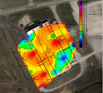
Mundell was retained by an environmental consultant to use the Refraction Microtremor technique (a passive seismic method) to map out the subsurface geology beneath an active industrial site, in an attempt to locate any possible bedrock depressions and fracture zones which could be acting as preferential pathways for soil and groundwater impacts……Read More »
Geophysics Portfolio
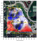
Ground Penetrating Radar Analysis of a Concrete Spillway
Mundell conducted a non-invasive, high-resolution, ground penetrating radar (GPR) survey of a concrete spillway to map the location of potential voids below the concrete after a significant outflow of water was detected from beneath the base of the spillway. The GPR investigation revealed the source of the outflow from beneath the spillway, and verified that the sub-base materials were sound. …..Read More »
Geothermal System Design using Geophysics
As part of the preliminary subsurface evaluation for the Ball State University Geothermal project, Mundell conducted surface two-dimensional resistivity testing and downhole geophysical logging to map the variation in geologic and hydrogeologic conditions beneath the site. This data proved extremely useful in the bidding process for the well installations, and for establishing and drilling specifications for the geothermal wells. …..Read More »
Geophysical Survey Rescues Town Water Supply
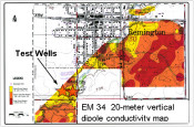
Mundell conducted a groundwater resources survey for a town which was experiencing water shortages, utilizing EM34 deep conductivity mapping. The conductivity survey was used locate favorable areas to drill. Each new production well location encountered more than 20 ft. of additional sand and gravel that had not been encountered before, and produced in excess of 800 gpm……Read More »
Geophysical Survey of Former Chemical Manufacturing Site
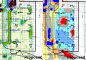
During a preliminary investigation prior to the construction of an industrial facility, Mundell personnel completed a multi-faceted electromagnetic (EM) geophysical survey to locate and characterize concealed metallic objects such as underground storage tanks, process piping and utilities, as well as to map variations in the possible fill materials present from any former operations. Based on anomalies discovered, Mundell provided cost estimates for waste materials handling to the client for project planning purposes, and final estimated quantities were within 5 % of those determined from the geophysical survey……Read More »