Mundell & Associates, Inc.

Consulting Professionals for the Earth and the Environment

  • Careers
  • Contact
  • Español
call us at (317) 630-9060
110 S. Downey Ave, Indianapolis, IN 46219 | Fax: (317) 630-9065
  •  
  • Company
    • About Us
    • Our Staff
    • Mission and Vision
    • Social Mission
    • Hablamos Español
    • Careers
    • Contact
  • Services
  • Industry Solutions
  • Portfolio
  • News
Discuss your projectall news
You are here: Home / Portfolio / Refraction Microtremor as a Tool to Map Bedrock Fractures

Refraction Microtremor as a Tool to Map Bedrock Fractures

portfolio typeCase Historiespdf iconDownload this as PDFPosted on June 22, 2012

A slice map showing bedrock fracture zones based on shear wave velocity values obtained from a Refraction Microtremor survey.

Challenge

Mundell was retained by an environmental solutions firm to use non-destructive geophysical methods to map out the subsurface geology beneath an industrial site in an attempt to locate any possible bedrock features, bedrock depressions and fracture zones, that could be acting as pathways for soil and groundwater impacts. The challenge in this particular case was the conditions of this Site, it was an active industrial facility with high levels of electromagnetic and seismic interference. Due to these conditions, Mundell chose to image the upper 45 feet of the subsurface by the use of naturally-occurring seismic noise of the Site to determine the shear-wave velocities of the upper geological layers through the Refraction Microtremor (ReMi) method.

Action

ReMi data is collected using a standard conventional seismograph and standard vertical P wave geophones. S-wave velocity profiles are generated by analyzing the spectrum of surface wave phase velocities and frequencies, and performing inversion modeling on the selected dispersion curve. For this geophysical investigation, five (5) ReMi profile lines were collected, using surface waves generated by the ongoing site activities as the energy source. The processing of the 5 profile lines involved three main steps: Velocity Spectral Analysis, Rayleigh Phase Velocity Dispersion Pickling and Shear Wave Velocity Modeling.
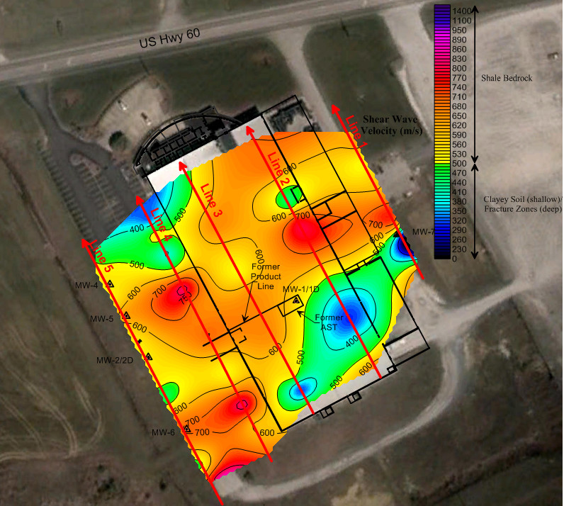
Results

In general, the five profiles all showed a similar pattern, with an upper soil layer of low shear wave velocity (200-500 m/s) overlaying a layer of moderate to high velocity bedrock (500-1500 m/s) which is intermixed with several low velocity zones (<500 m/s). The general geologic pattern of these sections was interpreted to be clayey soils overlying shale bedrock, in which several fracture zones were present. This interpretation was consistent with the actual field data obtained from the boring logs available to Mundell, which were advanced in close proximity to several of the ReMi lines.

more information Learn about our related services (Environmental Applications)

Similar Portfolio Items

  • Multimethod Geophysical Characterization of Fault Systems for Environmental Planning
  • Geophysical and Environmental Investigation Synthesis to Delineate Dual BTEX and MTBE Plume Migration via Preferential Channels
  • Former Salt Storage Site: Geophysical and Environmental Investigation to Delineate a Chloride Plume Impacting Public Drinking Water Supply Wells

Discuss your projectall news

Portfolio

Case Histories (130)
Presentations (155)
Publications (60)
all news View full portfolio

Latest News

  • John Mundell reflects on the legacy of Pope Francis and his concern for our common home May 27, 2025
  • Progress and Challenges for the Future of Indiana Water Resources January 28, 2025
  • Merry Christmas and Happy New Year from Mundell! December 23, 2024

Join our mailing list

News

John Mundell reflects on the legacy of Pope Francis and his concern for our common home

May 27, 2025in Community Involvement

Merry Christmas and Happy New Year from Mundell!

December 23, 2024in Company News

Using IndianaMap and web-based GIS to protect drinking water

December 3, 2024in Company News

Emissions Reporting and Air Dispersion Modeling Allows Tracking of Indy’s Air Pollutants

July 30, 2024in Science and Environment

Our Affiliations

- Midwestern States Environmental Consultants Association
- Environmental & Engineering Geophysical Society
- Professional Geologists of Indiana, Inc.
- National Groundwater Association
- American Societies of Chemical / Civil Engineers
- Association of Environmental and Engineering Geologists
- Indiana Association for Environmental Professionals
- Geological Society of America
- Indiana Geographic Information Council
- Economy of Communion

.....and more more affiliations

Be Inspired

  • Tuesday, December 2, 2025
    EPA established in 1970
Download calendarGet full calendar ICAL· Google Calendar

Giving Tuesday = Giving to Mother Earth

Find a way to give back this week, either to a local environmentally friendly initiative or national charity. Here are some ideas for those in the Indianapolis!

  • Keep Indianapolis Beautiful
  • Hoosier Environmental Council
  • Indiana Serra Club
  • Eco-organizations from Indiana Living Green
  • 21 Environmental Charities You Should Know About
.....see all tips more tips

Copyright © 2025 · Mundell & Associates, Inc. · 110 S. Downey Avenue, Indianapolis, IN 46219 · (317) 630-9060 · Privacy Policy · Terms of Use · Sitemap