Mundell & Associates, Inc.

Consulting Professionals for the Earth and the Environment

  • Careers
  • Hablamos Español
COVID-19 Policies
call us at (317) 630-9060
110 S. Downey Ave, Indianapolis, IN 46219 | Fax: (317) 630-9065
  •  
  • Company
    • About Us
    • Our Staff
    • Mission and Vision
    • Social Mission
    • Hablamos Español
    • Careers
    • Contact
  • Services
  • Industry Solutions
  • Portfolio
  • News
Discuss your projectall news
You are here: Home / Portfolio / Ground Penetrating Radar Analysis of a Concrete Spillway

Ground Penetrating Radar Analysis of a Concrete Spillway

portfolio typeCase Historiespdf iconDownload this as PDFPosted on June 22, 2012

A GPR slice map detailing potential voids in the concrete spillway.

Challenge

Engineers observed with concern significant outflow of water from beneath the base of the concrete spillway of the earthen dam at Lincoln State Park near Santa Claus, Indiana. Observations of flow patterns over the spillway indicate that water may be flowing through voids beneath the slabs, potentially resulting in erosional damage to the subbase. Although the concrete slabs of the spillway were level and unbroken, the purpose of the study was to locate voids before any damage occurred. In order to keep project costs to a minimum, the project engineer commissioned a geophysical investigation to map the location of potential voids below the concrete using non-destructive means. Identified voids underneath the spillway were to be remediated with grout pumped into the subbase of the concrete.

Technical Approach

Based on the project objectives, a high-resolution ground penetrating radar (GPR) survey was recommended to image the concrete and potential voids. Mundell has found that three-dimensional time-slice amplitude mapping is a rapid and cost-effective method to process and analyze very large GPR datasets such as this one. This method is used to composite a grid of vertical GPR profiles into a three-dimensional model that can be sliced horizontally to produce a map of the GPR response over any user-defined depth interval.

Results

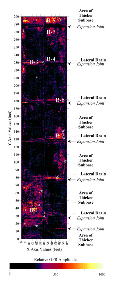
After processing and analyzing the composited average amplitude GPR response at various depth slices, the 1.20 to 2.00 feet depth interval map was selected as most relevant to the project objectives (see Figure). Test borings of the high amplitude anomalies on this map (B-1 through B-7) indicated areas of thicker subbase materials as well a system of lateral sub concrete drains installed in anticipation of water flow beneath the spillway. The GPR investigation revealed the source of the outflow from beneath the slabs and verified that the subbase materials were sound.

more information Learn about our related services (Engineering and Construction)

Similar Portfolio Items

  • Subsurface Imaging of Historic Canal Aqueduct Failure
  • Climate Change and the Public Forum: Communicating Geotechnical Engineering Concepts in a World of Suspicion and Mistrust
  • Ohio River Levee Seepage and Stability Evaluation Using Geophysical Characterization

Discuss your projectall news

all portfolio View entire portfolio

Portfolio Filter

  • Reset All

Text Search

News

Notice about COVID-19 policies

March 24, 2020in Company News

Featured: Mundell conducts environmental sampling in Franklin, Indiana

June 29, 2018in Science and Environment

Christmas Doll Project

January 6, 2021in Community Involvement

Merry Christmas and Happy Holidays from Mundell!

December 23, 2020in Company News

EPA Celebrates 50 Years of Drinking Water Research and Protection

December 2, 2020in Company News

Mundell Completes Environmental Review as Part of a Community Collaboration in Delaware County

November 5, 2020in Science and Environment

Our Affiliations

- Midwestern States Environmental Consultants Association
- Environmental & Engineering Geophysical Society
- Professional Geologists of Indiana, Inc.
- National Ground Water Association
- American Societies of Chemical / Civil Engineers Engineers without Borders
- Association of Environmental and Engineering Geologists
- Indiana Association for Environmental Professionals
- Geological Society of American
- Indiana Circular Economy Initiative
- Economy of Communion
- Indiana Recycling Coalition

.....and more more affiliations

Be Inspired

Loading...
Download calendarGet full calendar ICAL· Google Calendar

Check Your Heating Ducts

To ensure that as much warm air as possible is delivered through your central system, check the ductwork and wrap any leaks with duct mastic. Distribution losses (what’s lost while air is transported from your furnace through ductwork to the vents) often amounts to 30%. So, sealing ductwork could increase efficiency and the warm air you receive considerably … keeping you warmer and making your furnace work less.

Source: EPA

.....see all tips more tips

Copyright © 2021 · Mundell & Associates, Inc. · 110 S. Downey Avenue, Indianapolis, IN 46219 · (317) 630-9060 · Privacy Policy · Terms of Use · Sitemap