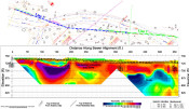
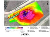
Mundell used photo-lineament analysis in conjunction with EM-34 terrain conductivity mapping, and 2-D resistivity profiling, to map out all karst features present beneath the site of a proposed large scale commercial district. This allowed the structural engineers to account for potential obstacles prior to development, with no surprises later on……Read More »
All Case Histories
Bedrock Mapping Using Seismic Refraction and 2-D Resistivity
Mundell performed a 2D resistivity and seismic refraction survey for a municipality in western Ohio, to map the top of bedrock and estimate rippability along a 5,100 foot section of a proposed sewer alignment. The twelve (12) resistivity and seismic lines collected along the extremely rugged terrain not only resulted in successful mapping of the soil bedrock interface, but also yielded information regarding the rock type and the state of competency……Read More »
Soil Vapor Extraction and Air Sparging Removal Action on EPA CERCLA Site at Former Residential Dry Cleaner
In 2005, the EPA issued an order to remove PCE contamination from a former dry cleaners site as it presented a potential endangerment to the public health. Mundell was contracted to develop a plan to achieve unsaturated soils and groundwater cleanup goals while controlling PCE soil gas vapors that had intruded into the foundations of residences. In 2013, after 7 years of Mundell’s remediation system and techniques, the EPA approved completion of the soil removal action, indicating that on-site PCE soil source had been remediated. Approximately 1.65 tons of PCE had been removed by the system. Mundell continues to monitor groundwater to track progress of reductive de-chlorination in the residual off-site chlorinated groundwater plume……Read More »
Blast Monitoring During Demolition
During the demolition of the former Keystone Towers in Indianapolis, Indiana, Mundell was contracted to monitor ground vibrations, to verify that seismic levels did not exceed the pre-established standards……Read More »
Conductivity Mapping for Salt Water Impact Delineation
As part of the pre-sale, due diligence environmental site assessments conducted over three petroleum production facilities, Mundell performed an EM-31 terrain conductivity survey across a total of 22 acres of rough terrain to delineate the lateral extent of any salt water impacts that may be present beneath three (3) sites, due to faulty tanks, piping, or engineering controls. Based on the electrical conductivity map, Mundell was able to approximate the acreage of impacts which would need to be remediated prior to the sale of the properties……Read More »