
Mundell performed a geophysical investigation to locate bedrock fracture/weathering zones in limestone bedrock that were believed to be controlling both lateral and vertical contaminant migration across a travel plaza site in central Kentucky……Read More »
Geophysics Portfolio
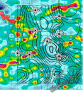
Thermal Mapping of a Landfill Area
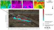
Mundell used two thermal imaging devices to accurately delineate surface thermal anomalies generated by the decaying organic debris at a site of an existing landfill……Read More »
Geophysical Search for Buried Waste at an Industrial Facility
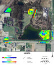
In the past, unknown quantities of waste materials related to plant production were buried across an active industrial site in western Indiana. Mundell used electromagnetic (EM) geophysical methods to locate the areas containing buried waste materials across four (4) areas of concern. …..Read More »
Subsurface Site Characterization Using Downhole Logging Tools
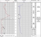
Mundell was contacted to address data deficiencies related to well construction details for a series of existing monitoring wells. This data included geologic information about select monitoring wells using borehole geophysical logging, horizontal and vertical survey data for each monitoring well and hydraulic conductivity of select wells using slug and bail testing. Upon completion of the survey, it became apparent that not only was information lacking from the previous report, but information regarding the construction of certain wells was incorrect……Read More »
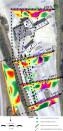
Karst Feature Delineation Prior to Commercial Development
Mundell used photo-lineament analysis in conjunction with EM-34 terrain conductivity mapping, and 2-D resistivity profiling, to map out all karst features present beneath the site of a proposed large scale commercial district. This allowed the structural engineers to account for potential obstacles prior to development, with no surprises later on……Read More »