Mundell & Associates, Inc.

Consulting Professionals for the Earth and the Environment

  • Careers
  • Contact
  • Español
call us at (317) 630-9060
110 S. Downey Ave, Indianapolis, IN 46219 | Fax: (317) 630-9065
  •  
  • Company
    • About Us
    • Our Staff
    • Mission and Vision
    • Social Mission
    • Hablamos Español
    • Careers
    • Contact
  • Services
  • Industry Solutions
  • Portfolio
  • News
Discuss your projectall news
You are here: Home / Portfolio / Thermal Mapping of a Landfill Area

Thermal Mapping of a Landfill Area

portfolio typeCase Historiespdf iconDownload this as PDFPosted on July 8, 2013

Challenge

Recently, Mundell provided mapping services to an environmental consultant to delineate zones of high thermal activity along the northern boundary of an existing sloping landfill. At some point in the past, the northern portion of the landfill was used to dispose of organic debris. Overtime, microbial activities on the organic debris produced an exothermic reaction, thereby increasing the subsurface temperature. This temperature increase was sufficient enough to generate spontaneous combustion, and thus posed a potential hazard to the landfill.
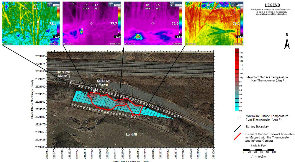
Action

Mundell used an infrared thermometer combined with an infrared camera to provide temperature readings across the survey area. These two techniques used in conjugation allowed for delineation to be made on the zones responsible for the temperature increase, which were then subsequently removed.

Results

Despite the drastic topographic relief and dense vegetation of the survey area, the use of two thermal imaging devices allowed for an accurate delineation of surface thermal anomalies generated by the decaying organic debris. This investigation essentially reduced the size of the area in question by half.

thermal-mapping-landfill

more information Learn about our related services (Environmental Applications)

Similar Portfolio Items

  • Multimethod Geophysical Characterization of Fault Systems for Environmental Planning
  • Geophysical and Environmental Investigation Synthesis to Delineate Dual BTEX and MTBE Plume Migration via Preferential Channels
  • Former Salt Storage Site: Geophysical and Environmental Investigation to Delineate a Chloride Plume Impacting Public Drinking Water Supply Wells

Discuss your projectall news

Portfolio

Case Histories (130)
Presentations (155)
Publications (60)
all news View full portfolio

Latest News

  • John Mundell receives Purdue University’s prestigious Civil Engineering Alumni Achievement Award April 14, 2026
  • Merry Christmas and Happy New Year from Mundell! December 19, 2025
  • John Mundell reflects on the legacy of Pope Francis and his concern for our common home May 27, 2025

Join our mailing list

News

John Mundell receives Purdue University’s prestigious Civil Engineering Alumni Achievement Award

April 14, 2026in Company News

Merry Christmas and Happy New Year from Mundell!

December 19, 2025in Company News

John Mundell reflects on the legacy of Pope Francis and his concern for our common home

May 27, 2025in Community Involvement

Using IndianaMap and web-based GIS to protect drinking water

December 3, 2024in Company News

Our Affiliations

- Midwestern States Environmental Consultants Association
- Environmental & Engineering Geophysical Society
- Professional Geologists of Indiana, Inc.
- National Groundwater Association
- American Societies of Chemical / Civil Engineers
- Association of Environmental and Engineering Geologists
- Indiana Association for Environmental Professionals
- Geological Society of America
- Indiana Geographic Information Council
- Economy of Communion

.....and more more affiliations

Be Inspired

  • Saturday, April 18, 2026
    Free Entrance to National Parks (National Park Opening Weekend)

    National Parks by state

Download calendarGet full calendar ICAL· Google Calendar

Download a Map for Your Next Outdoor Adventure

Reading maps is fun and can tell you a lot about your local environment. The U.S. Geological Survey has been producing detailed topographic maps for more than 125 years. Many are free to download through the USGS Map Store.

Source: Download Maps

.....see all tips more tips

Copyright © 2026 · Mundell & Associates, Inc. · 110 S. Downey Avenue, Indianapolis, IN 46219 · (317) 630-9060 · Privacy Policy · Terms of Use · Sitemap