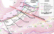
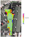
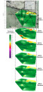
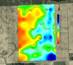
Mundell performed an EM-34 conductivity survey over a 66 acre site to confirm the result of 8 preliminary test borings for an industrial water well. The test borings indicated very little sand and gravel resources were present. After performing the survey and analyzing the results, Mundell’s geophysical department showed the borings were just advanced in poor locations and abundant sand and gravel were indeed present beneath the site……Read More »
Portfolio
Mundell & Associates is a small consulting company with large-company credentials and significant experience with some of the most challenging and diverse environmental concerns.
Our project portfolio (which includes case histories, publications, and presentations) covers the world and includes time sensitive investigations as well as long term remediation and monitoring. Clients benefit from a cross disciplinary approach to problem solving and depend on our abilities to communicate complex scientific and engineering principles.
2-D Resistivity for Mapping Seepage Features in Limestone Bedrock
A regional mining company observed an unexplained, continual decrease in the water level of their mine water lake. As the existing dam appeared to be intact, the lead engineer assumed that subterranean karst features within the bedrock were responsible for the seepage and asked Mundell to perform a detailed geophysical survey. After collecting eight 2-D resistivity profiles across the site, all of which showed some level of karst development within the bedrock, we were able to detail the primary flow pathways, and make recommendations to the mine regarding the remediation of the seepage……Read More »
Geotechnical/Geophysical Evaluation of Karst Limestone Sites (2002)
Byer, G. B., Mundell, J. A. and Vanderlaan, J. H.M., “Geotechnical/Geophysical Evaluation of Karst Limestone Sites – A Case History,” SAGEEP 2002, Environmental and Engineering Geophysical Society, February, Los Vegas, Nevada. Paper: 13CAV2, Presentation: February 13, 2002.
Search for Underground Storage Tanks on an Active Car Dealership
Mundell was contacted to scan a 0.5 acre portion of a used car dealership for any underground storage tanks (USTs) that may have been present. To do so, Mundell performed a high-resolution metal detection survey in conjunction with limited ground penetrating radar (GPR) scanning. Mundell identified three different anomalies which were interpreted as a possible UST, a small former fuel oil UST, and a former tank pit with scrap metal still present, respectively. Test pits conducted in these areas confirmed the interpretations……Read More »
Karst Feature Mapping Beneath a Proposed Substation Location
Mundell was hired by an electric company in southern Indiana to provide insight into the development of karst features beneath the site of a substation expansion project. To map out karst features across the site, Mundell collected 6, 2D resistivity profiles to measure the variation in the electrical properties of the upper 100 feet of subsurface. …..Read More »