Mundell & Associates, Inc.

Consulting Professionals for the Earth and the Environment

  • Careers
  • Contact
  • Español
call us at (317) 630-9060
110 S. Downey Ave, Indianapolis, IN 46219 | Fax: (317) 630-9065
  •  
  • Company
    • About Us
    • Our Staff
    • Mission and Vision
    • Social Mission
    • Hablamos Español
    • Careers
    • Contact
  • Services
  • Industry Solutions
  • Portfolio
  • News
Discuss your projectall news
You are here: Home / Portfolio / Conductivity Mapping to Locate a Sand and Gravel Aquifer

Conductivity Mapping to Locate a Sand and Gravel Aquifer

portfolio typeCase Historiespdf iconDownload this as PDFPosted on April 14, 2012

Electrical Conductivity Map

An EM-34 electrical conductivity map indicating the limits of sand and gravel resource across the site. Low conductivity values equate to sand and gravel.

Challenge

Mundell was contracted to study the extent of sand and gravel resources beneath a 66 acre site in eastern Ohio. In the vicinity of the site, depth to bedrock ranges from 40 to 150 feet, with the unconsolidated soils above bedrock consisting predominantly of fine-grained glacial till with lesser amounts of sand and gravel.

Action

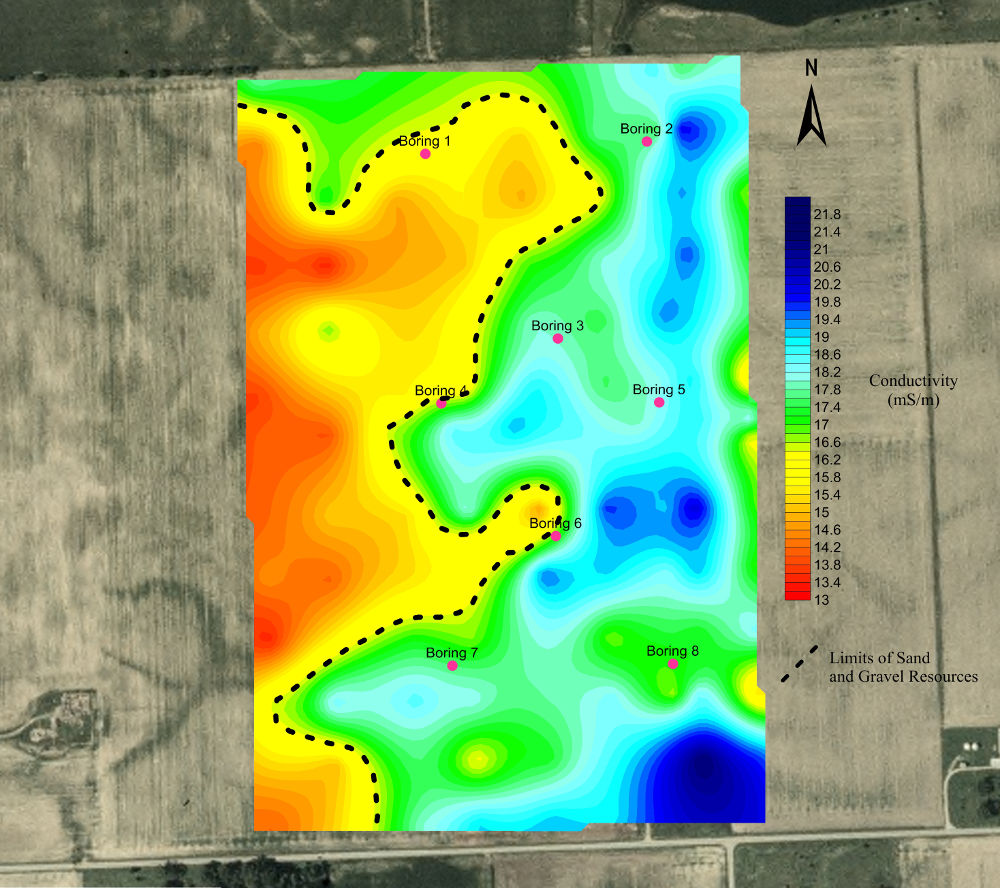
Prior to the geophysical study, eight (8) test borings had been advanced across the site. Based on these borings, it appeared that very little aquifer materials were present. To verify this data, Mundell collected a 60 by 60 meter grid of EM-34 conductivity data. This allowed for a delineation of the overburden materials present at approximately 40 feet below ground surface (BGS). Based on the conductivity data, it appears that at 40 feet BGS, sand and gravel (red to yellow in color) are present beneath most of the western half of the site, with only one of the test borings (Boring 1) being located in the aggregate reserve. Vertical delineation of this reserve body was determined using two-dimensional resistivity profiling, which indicated that thickness ranged from 30 to 50 feet.

Results

The unlucky placement of 8 standard test borings advanced across the site suggested very little resources were present. However, a deep EM conductivity survey performed by Mundell indicated that the borings were just advanced in poor locations, and that abundant sand and gravel were indeed present. Had geophysics not been used, a potentially lucrative site for an industrial water well may have gone ignored. Geophysics provided a true estimate of the water resources beneath the site.

more information Learn about our related services (Geophysics)

Similar Portfolio Items

  • Dam Rehabilitation Guided by Geophysical Characterization
  • Bedrock Mapping Along Combined Sewer Overflow Storage Alignment
  • Geophysical Characterization in Support of Levee Flood Protection Area Seepage Evaluation

Discuss your projectall news

Portfolio

Case Histories (130)
Presentations (155)
Publications (60)
all news View full portfolio

Latest News

  • John Mundell reflects on the legacy of Pope Francis and his concern for our common home May 27, 2025
  • Progress and Challenges for the Future of Indiana Water Resources January 28, 2025
  • Merry Christmas and Happy New Year from Mundell! December 23, 2024

Join our mailing list

News

John Mundell reflects on the legacy of Pope Francis and his concern for our common home

May 27, 2025in Community Involvement

Merry Christmas and Happy New Year from Mundell!

December 23, 2024in Company News

Using IndianaMap and web-based GIS to protect drinking water

December 3, 2024in Company News

Emissions Reporting and Air Dispersion Modeling Allows Tracking of Indy’s Air Pollutants

July 30, 2024in Science and Environment

Our Affiliations

- Midwestern States Environmental Consultants Association
- Environmental & Engineering Geophysical Society
- Professional Geologists of Indiana, Inc.
- National Groundwater Association
- American Societies of Chemical / Civil Engineers
- Association of Environmental and Engineering Geologists
- Indiana Association for Environmental Professionals
- Geological Society of America
- Indiana Geographic Information Council
- Economy of Communion

.....and more more affiliations

Be Inspired

  • Monday, June 16, 2025
    National Pollinator Week

    Polinator Partnership website

Download calendarGet full calendar ICAL· Google Calendar

Reduce Erosion and Preserve Topsoil

Land degradation has increased around the world as our human activities pollute or degrade the quality of soil, affecting not only food production but the overall ecosystems. What can we do locally to preserve our soil?

  • Rotate the crops you grow in your garden.
  • Use local mulch, especially in bare stops to help plants ground and prevent water runoff.
  • Plant large plants such as trees and hedges to reduce wind speed.
  • Minimize soil compaction by create permanent walkways and encouraging people to stay on them.
.....see all tips more tips

Copyright © 2025 · Mundell & Associates, Inc. · 110 S. Downey Avenue, Indianapolis, IN 46219 · (317) 630-9060 · Privacy Policy · Terms of Use · Sitemap