Mundell & Associates, Inc.

Consulting Professionals for the Earth and the Environment

  • Careers
  • Contact
  • Español
call us at (317) 630-9060
110 S. Downey Ave, Indianapolis, IN 46219 | Fax: (317) 630-9065
  •  
  • Company
    • About Us
    • Our Staff
    • Mission and Vision
    • Social Mission
    • Hablamos Español
    • Careers
    • Contact
  • Services
  • Industry Solutions
  • Portfolio
  • News
Discuss your projectall news
You are here: Home / Portfolio / Geophysical Survey Locates Buried Conductive Objects at Industrial Landfill Site

Geophysical Survey Locates Buried Conductive Objects at Industrial Landfill Site

portfolio typeCase Historiespdf iconDownload this as PDFPosted on June 23, 2012

Multi-faceted geophysical survey

Challenge

A records search and personal interviews at an aluminum industrial facility had reportedly indicated that landfill materials (in particular, carbon cathodes) had been buried in an approximately 53-acre area behind the facility. However, no precise indications were made as to the exact locations of these materials or to the extent of the actual area of buried materials. Prior to development of the property, the client was interested in locating and identifying these buried materials to aid in the direction of test pits over the 53-acre site. Given the size of the site, Mundell was asked to perform a large scale geophysical survey as a guide for the location of test pits.

Action

To accomplish the study objectives, Mundell personnel completed a multi-faceted geophysical survey using advanced electromagnetic equipment integrated with GPS to locate and characterize concealed conductive and metallic objects, and to map variations in different fill materials.

Results

The results indicated several large areas of highly conductive materials with substantially higher conductivities than the background soils (Areas A through H in the above figure). Using the geophysical results, Mundell recommended test pits for determining the expected character of the buried materials. The excavations uncovered significant accumulations of spent buried carbon material, including several virgin carbon cathodes and anodes, metallic objects, and general construction debris as shown in the figure to the left. A similar survey was performed at a later time in other areas at the facility which were also suspected of containing buried conductive objects. Comparable results were obtained during this survey.

Summary Map

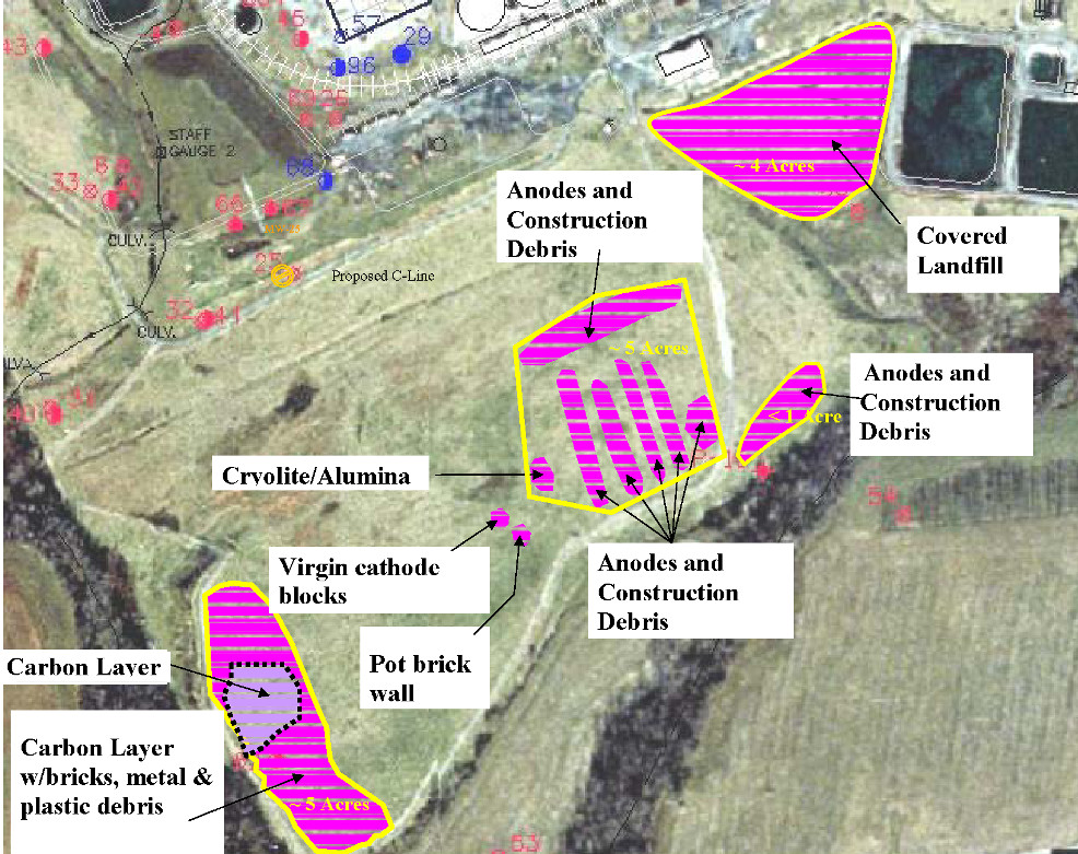
Results summary map showing various conductive fill materials buried in the industrial landfill.

more information Learn about our related services (Geophysics) and industry solutions (Industrial and Auto)

Similar Portfolio Items

  • Groundwater Resource Assessment: Long-Term Sustainability
  • Dam Rehabilitation Guided by Geophysical Characterization
  • Bedrock Mapping Along Combined Sewer Overflow Storage Alignment

Discuss your projectall news

Portfolio

Case Histories (130)
Presentations (155)
Publications (60)
all news View full portfolio

Latest News

  • John Mundell receives Purdue University’s prestigious Civil Engineering Alumni Achievement Award April 14, 2026
  • Merry Christmas and Happy New Year from Mundell! December 19, 2025
  • John Mundell reflects on the legacy of Pope Francis and his concern for our common home May 27, 2025

Join our mailing list

News

John Mundell receives Purdue University’s prestigious Civil Engineering Alumni Achievement Award

April 14, 2026in Company News

Merry Christmas and Happy New Year from Mundell!

December 19, 2025in Company News

John Mundell reflects on the legacy of Pope Francis and his concern for our common home

May 27, 2025in Community Involvement

Using IndianaMap and web-based GIS to protect drinking water

December 3, 2024in Company News

Our Affiliations

- Midwestern States Environmental Consultants Association
- Environmental & Engineering Geophysical Society
- Professional Geologists of Indiana, Inc.
- National Groundwater Association
- American Societies of Chemical / Civil Engineers
- Association of Environmental and Engineering Geologists
- Indiana Association for Environmental Professionals
- Geological Society of America
- Indiana Geographic Information Council
- Economy of Communion

.....and more more affiliations

Be Inspired

  • Saturday, April 18, 2026
    Free Entrance to National Parks (National Park Opening Weekend)

    National Parks by state

Download calendarGet full calendar ICAL· Google Calendar

Download a Map for Your Next Outdoor Adventure

Reading maps is fun and can tell you a lot about your local environment. The U.S. Geological Survey has been producing detailed topographic maps for more than 125 years. Many are free to download through the USGS Map Store.

Source: Download Maps

.....see all tips more tips

Copyright © 2026 · Mundell & Associates, Inc. · 110 S. Downey Avenue, Indianapolis, IN 46219 · (317) 630-9060 · Privacy Policy · Terms of Use · Sitemap