Mundell & Associates, Inc.

Consulting Professionals for the Earth and the Environment

  • Careers
  • Contact
  • Español
call us at (317) 630-9060
110 S. Downey Ave, Indianapolis, IN 46219 | Fax: (317) 630-9065
  •  
  • Company
    • About Us
    • Our Staff
    • Mission and Vision
    • Social Mission
    • Hablamos Español
    • Careers
    • Contact
  • Services
  • Industry Solutions
  • Portfolio
  • News
Discuss your projectall news
You are here: Home / Portfolio / Geophysical Mapping of Cultural Resource Area near Pipeline Crossing

Geophysical Mapping of Cultural Resource Area near Pipeline Crossing

portfolio typeCase Historiespdf iconDownload this as PDFPosted on June 22, 2012

Site Magnetic Anomaly Map

A magnetic anomaly map used to locate areas of potential archeological importance. Anomalous zones are denoted by black dashed lines.

Challenge

The construction of the 42-inch diameter natural gas pipeline across Indiana involved the crossing of multiple areas of pre-historic and historic cultural significance. In one such area, where there was concern regarding the impact of the construction on drinking water quality, groundwater monitoring wells needed to be installed. As part of that effort, the proposed wells needed to be placed in areas across the site not known to contain any features of potential cultural significance. Mundell was contracted by REX to evaluate the site so that placement of the wells could avoid disturbance of any such archaeologically significant areas.

Technical Approach

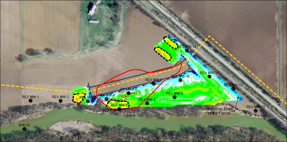
Mundell performed time domain electromagnetic terrain conductivity mapping using an EM-38 conductivity meter manufactured by Geonics, Ltd., and magnetic field mapping using the high resolution G-858 Cesium magnetometer manufactured by Geometrics Ltd. The EM-38 and G-858 data were collected by securing the instruments to a rigid plastic sledge and towing them behind an all terrain vehicle. The data were collected along lines spaced approximately 1 to 1.5 meters apart with an in-line data point spacing of 0.3 meters. Positioning data were provided by a Trimble Ag114 global positioning system (GPS) receiver with real-time satellite based differential correction. Once the data were gathered, they were transferred to a computer and imported into Surfer Version 8.0 for contouring and plotting as color-filled contour maps of terrain conductivity and anomalous magnetic field strength (shown in the inset figure above).

Results

This approach provided not only left potential historic site features in a pristine condition, but it also gave the pipeline company peace of mind, knowing that they had exercised their due diligence.

more information Learn about our related services (Archaeological Studies)

Similar Portfolio Items

  • Geophysical and Detailed Site Mapping of Cemetery Grounds
  • Use of Geophysical Surveys for Archaeological Excavation Planning
  • Geophysical Imaging in Support of Historic and Cultural Resource Studies for Land Development (2009)

Discuss your projectall news

Portfolio

Case Histories (130)
Presentations (155)
Publications (60)
all news View full portfolio

Latest News

  • John Mundell reflects on the legacy of Pope Francis and his concern for our common home May 27, 2025
  • Progress and Challenges for the Future of Indiana Water Resources January 28, 2025
  • Merry Christmas and Happy New Year from Mundell! December 23, 2024

Join our mailing list

News

John Mundell reflects on the legacy of Pope Francis and his concern for our common home

May 27, 2025in Community Involvement

Merry Christmas and Happy New Year from Mundell!

December 23, 2024in Company News

Using IndianaMap and web-based GIS to protect drinking water

December 3, 2024in Company News

Emissions Reporting and Air Dispersion Modeling Allows Tracking of Indy’s Air Pollutants

July 30, 2024in Science and Environment

Our Affiliations

- Midwestern States Environmental Consultants Association
- Environmental & Engineering Geophysical Society
- Professional Geologists of Indiana, Inc.
- National Groundwater Association
- American Societies of Chemical / Civil Engineers
- Association of Environmental and Engineering Geologists
- Indiana Association for Environmental Professionals
- Geological Society of America
- Indiana Geographic Information Council
- Economy of Communion

.....and more more affiliations

Be Inspired

  • Monday, June 16, 2025
    National Pollinator Week

    Polinator Partnership website

Download calendarGet full calendar ICAL· Google Calendar

Reduce Erosion and Preserve Topsoil

Land degradation has increased around the world as our human activities pollute or degrade the quality of soil, affecting not only food production but the overall ecosystems. What can we do locally to preserve our soil?

  • Rotate the crops you grow in your garden.
  • Use local mulch, especially in bare stops to help plants ground and prevent water runoff.
  • Plant large plants such as trees and hedges to reduce wind speed.
  • Minimize soil compaction by create permanent walkways and encouraging people to stay on them.
.....see all tips more tips

Copyright © 2025 · Mundell & Associates, Inc. · 110 S. Downey Avenue, Indianapolis, IN 46219 · (317) 630-9060 · Privacy Policy · Terms of Use · Sitemap