Mundell & Associates, Inc.

Consulting Professionals for the Earth and the Environment

  • Careers
  • Contact
  • Español
call us at (317) 630-9060
110 S. Downey Ave, Indianapolis, IN 46219 | Fax: (317) 630-9065
  •  
  • Company
    • About Us
    • Our Staff
    • Mission and Vision
    • Social Mission
    • Hablamos Español
    • Careers
    • Contact
  • Services
  • Industry Solutions
  • Portfolio
  • News
Discuss your projectall news
You are here: Home / Portfolio / Use of Geophysical Surveys for Archaeological Excavation Planning

Use of Geophysical Surveys for Archaeological Excavation Planning

portfolio typeCase Historiespdf iconDownload this as PDFPosted on April 15, 2012

Resistivity Profile

A 2D Electrical Resistivity Profile showing potential structural features at the archaeological site.

Challenge

Mundell was contacted to test the efficacy of combining magnetic methods, 2-D resistivity, and ground penetrating radar (GPR) techniques for pre-evaluating suspected Anasazi ruins, within selected areas of a site, prior to archaeological excavation at a prehistoric complex in Cortez, Colorado. The purpose of this survey was to provide significant insight into the shallow subsurface material characteristics, and also provide valuable aids in guiding excavation activities during a later field school.

Technical Approach

Mundell used Magnetics, 2-D resistivity imaging, and GPR over selected portions of the study area during a three-day study period. Magnetic data were collected with an G&G Geometrics Gradiometer at a 1-meter grid spacing. Vertical and lateral resistivity characteristics of the subsurface materials were determined using a 2-D Advanced Geosciences, Inc. (AGI) Sting R1 portable resistivity imaging system. GPR profiles were acquired using a Sensors & Software Noggin with shielded 250 MHz center-frequency antennas mounted to a Smart Cart with an odometer wheel for accurate positioning. A Noggin Plus digital video logger (DVL) was used to monitor the data in real time. Data were collected at a 0.5-meter line separation along selected lines in areas of interest. Preliminary analysis indicated a strong correlation of the GPR data with the results of the 2-D resistivity plan view maps.
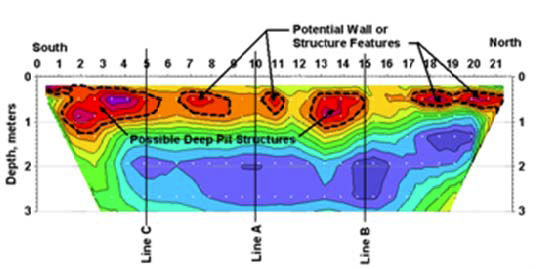
Results

Based on the geophysical survey results, significant archaeological structures were disclosed at a high percentage of anomalous areas exhibiting elevated resistivity and/or magnetic field gradient, or changes in the shallow material properties observed in the ground penetrating radar profile lines. A pueblo with connecting rooms, several deep storage pits, and three burials were identified. Use of multiple geophysical techniques allowed for cross-correlation of anomalous areas, enhancing the likelihood of finding features of significance.

more information Learn about our related services (Archaeological Studies)

Similar Portfolio Items

  • Geophysical Mapping of Cultural Resource Area near Pipeline Crossing
  • Geophysical and Detailed Site Mapping of Cemetery Grounds
  • Geophysical Imaging in Support of Historic and Cultural Resource Studies for Land Development (2009)

Discuss your projectall news

Portfolio

Case Histories (130)
Presentations (155)
Publications (60)
all news View full portfolio

Latest News

  • John Mundell reflects on the legacy of Pope Francis and his concern for our common home May 27, 2025
  • Progress and Challenges for the Future of Indiana Water Resources January 28, 2025
  • Merry Christmas and Happy New Year from Mundell! December 23, 2024

Join our mailing list

News

John Mundell reflects on the legacy of Pope Francis and his concern for our common home

May 27, 2025in Community Involvement

Merry Christmas and Happy New Year from Mundell!

December 23, 2024in Company News

Using IndianaMap and web-based GIS to protect drinking water

December 3, 2024in Company News

Emissions Reporting and Air Dispersion Modeling Allows Tracking of Indy’s Air Pollutants

July 30, 2024in Science and Environment

Our Affiliations

- Midwestern States Environmental Consultants Association
- Environmental & Engineering Geophysical Society
- Professional Geologists of Indiana, Inc.
- National Groundwater Association
- American Societies of Chemical / Civil Engineers
- Association of Environmental and Engineering Geologists
- Indiana Association for Environmental Professionals
- Geological Society of America
- Indiana Geographic Information Council
- Economy of Communion

.....and more more affiliations

Be Inspired

  • Monday, June 16, 2025
    National Pollinator Week

    Polinator Partnership website

Download calendarGet full calendar ICAL· Google Calendar

Reduce Erosion and Preserve Topsoil

Land degradation has increased around the world as our human activities pollute or degrade the quality of soil, affecting not only food production but the overall ecosystems. What can we do locally to preserve our soil?

  • Rotate the crops you grow in your garden.
  • Use local mulch, especially in bare stops to help plants ground and prevent water runoff.
  • Plant large plants such as trees and hedges to reduce wind speed.
  • Minimize soil compaction by create permanent walkways and encouraging people to stay on them.
.....see all tips more tips

Copyright © 2025 · Mundell & Associates, Inc. · 110 S. Downey Avenue, Indianapolis, IN 46219 · (317) 630-9060 · Privacy Policy · Terms of Use · Sitemap