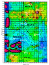
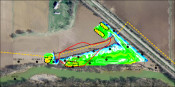
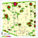
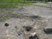
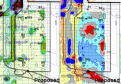
During a preliminary investigation prior to the construction of an industrial facility, Mundell personnel completed a multi-faceted electromagnetic (EM) geophysical survey to locate and characterize concealed metallic objects such as underground storage tanks, process piping and utilities, as well as to map variations in the possible fill materials present from any former operations. Based on anomalies discovered, Mundell provided cost estimates for waste materials handling to the client for project planning purposes, and final estimated quantities were within 5 % of those determined from the geophysical survey……Read More »
Portfolio
Mundell & Associates is a small consulting company with large-company credentials and significant experience with some of the most challenging and diverse environmental concerns.
Our project portfolio (which includes case histories, publications, and presentations) covers the world and includes time sensitive investigations as well as long term remediation and monitoring. Clients benefit from a cross disciplinary approach to problem solving and depend on our abilities to communicate complex scientific and engineering principles.
Geophysical Survey Provides a Basis for Brownfield Development Costs for Urban Site
Mundell personnel completed a multi-faceted geophysical survey of a 100-year old brownfield site, which had been used in the past as a warehouse, bar, restaurant, bakery, and dentist office, in order to identify suspected impacted and hazardous materials that may have been buried on the site. Using the quantities of materials estimated from the geophysical survey and the types of materials found at the site within the test pits, a cost estimate for developing the property ranged from about $430,000 to $600,000. This included the costs of excavation, transportation and landfill disposal of materials……Read More »
Geophysical Mapping of Cultural Resource Area near Pipeline Crossing
Mundell performed a magnetic and terrain conductivity survey along a section of pipeline right of way to evaluate for the presence of cultural resources. This approach proved invaluable in mapping cultural features so that they could be avoided and remain intact……Read More »
Geophysical and Detailed Site Mapping of Cemetery Grounds
Mundell used several geophysical methods to map out the extents of an old cemetery. This approach provided value both in terms of preserving the identity and locations of the known graves, and in offering insight into the locations of some unmarked graves. It was determined that high resolution conductivity mapping with a Geonics EM-38 combined with gridded GPR mapping appeared to have the best potential for mapping unmarked graves……Read More »
Geophysical Evaluation of Suspect Preferential Pathway for LPH Migration
Mundell used GPR to detect the presence of an un-documented, orphan UST located just south of a site undergoing active remediation. By performing a detailed comparison of the residual liquid phase hydrocarbon (LPH) material left in the tank with surrounding impacts on the property being remediated, Mundell was able to absolve the client of any fault for LPH in that portion of the site, saving thousands of dollars in remediation expenses. …..Read More »