Mundell & Associates, Inc.

Consulting Professionals for the Earth and the Environment

  • Careers
  • Contact
  • Español
call us at (317) 630-9060
110 S. Downey Ave, Indianapolis, IN 46219 | Fax: (317) 630-9065
  •  
  • Company
    • About Us
    • Our Staff
    • Mission and Vision
    • Social Mission
    • Hablamos Español
    • Careers
    • Contact
  • Services
  • Industry Solutions
  • Portfolio
  • News
Discuss your projectall news
You are here: Home / Portfolio / Geophysical Survey Provides a Basis for Brownfield Development Costs for Urban Site

Geophysical Survey Provides a Basis for Brownfield Development Costs for Urban Site

portfolio typeCase Historiespdf iconDownload this as PDFPosted on June 22, 2012

Terrain Conductivity Map at Brownfield Site

A terrain conductivity map, detailing variations in fill materials beneath the 100-year old brownfield site.

Challenge

A Phase I Environmental Site Assessment for a flat, gravel-covered, 1.3 acre parcel in an urban site in Indianapolis, Indiana indicated that it had been covered with multiple building structures over most of its 100 year use. Facilities had included warehouses, a bar, a restaurant, a baker, and a dentist. However, no records of building demolition had been found during the assessment, although it was suspected that debris from the structure razing had been disposed of on-site. Because of the desire to develop the property, the Phase I ESA recommended a subsurface investigation be conducted to identify suspected impacted and hazardous materials that may have been buried on the site. Due to the expected demolition debris, the use of test pits to uncover areas of concern was recommended. However, since no evidence existed as to where the pits should be located, Mundell was asked to perform a geophysical survey to guide the selection of test pit locations.

Action

To accomplish the study objectives, Mundell personnel completed a multi-faceted geophysical survey using electromagnetic and 2-D electrical resistivity equipment to locate and characterize concealed metallic objects such as underground storage tanks, steel drums, utilities and metallic debris, and to map variations in different fill materials.

Results

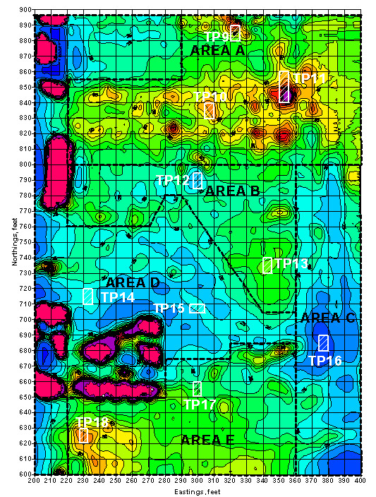
The results indicated significant metallic objects and five distinct areas of similar subsurface fill materials (Areas A through E in the above figure). Using the geophysical results, Mundell recommended the location of eighteen (18) test pits for determining the expected character of the buried materials. The excavations uncovered building and construction debris, concrete slabs, bricks, wood, sheet metal, scrap metal, and slag and ash (see to the left). No obvious chemically-impacted fill materials of concern or asbestos-containing materials were encountered. Using the quantities of materials estimated from the geophysical survey and the types of materials found at the site within the test pits, a cost estimate for developing the property ranged from about $430,000 to $600,000. This included the costs of excavation, transportation and landfill disposal of materials.

more information Learn about our related services (Environmental Applications) and industry solutions (Municipal)

Similar Portfolio Items

  • Groundwater Flow and Capture Zone Analysis of a Chlorinated Solvent Plume, Pump & Treat System, and nearby Municipal Well
  • Groundwater Protection Programs of Marion County, Indiana
  • Residential Drinking Water Impacts from Treated Utility Poles

Discuss your projectall news

Portfolio

Case Histories (130)
Presentations (155)
Publications (60)
all news View full portfolio

Latest News

  • John Mundell receives Purdue University’s prestigious Civil Engineering Alumni Achievement Award April 14, 2026
  • Merry Christmas and Happy New Year from Mundell! December 19, 2025
  • John Mundell reflects on the legacy of Pope Francis and his concern for our common home May 27, 2025

Join our mailing list

News

John Mundell receives Purdue University’s prestigious Civil Engineering Alumni Achievement Award

April 14, 2026in Company News

Merry Christmas and Happy New Year from Mundell!

December 19, 2025in Company News

John Mundell reflects on the legacy of Pope Francis and his concern for our common home

May 27, 2025in Community Involvement

Using IndianaMap and web-based GIS to protect drinking water

December 3, 2024in Company News

Our Affiliations

- Midwestern States Environmental Consultants Association
- Environmental & Engineering Geophysical Society
- Professional Geologists of Indiana, Inc.
- National Groundwater Association
- American Societies of Chemical / Civil Engineers
- Association of Environmental and Engineering Geologists
- Indiana Association for Environmental Professionals
- Geological Society of America
- Indiana Geographic Information Council
- Economy of Communion

.....and more more affiliations

Be Inspired

  • Saturday, April 18, 2026
    Free Entrance to National Parks (National Park Opening Weekend)

    National Parks by state

Download calendarGet full calendar ICAL· Google Calendar

Download a Map for Your Next Outdoor Adventure

Reading maps is fun and can tell you a lot about your local environment. The U.S. Geological Survey has been producing detailed topographic maps for more than 125 years. Many are free to download through the USGS Map Store.

Source: Download Maps

.....see all tips more tips

Copyright © 2026 · Mundell & Associates, Inc. · 110 S. Downey Avenue, Indianapolis, IN 46219 · (317) 630-9060 · Privacy Policy · Terms of Use · Sitemap