
Mundell & Associates offers a variety of water locating services for the agriculture and other industries.
What is the process?
Mundell begins by establishing the property location and boundaries. From there, an in-depth study of existing hydrogeologic and geologic records is conducted. This is known as a Hydrogeologic Desktop Study and typically includes
- Review of documented aquifer types (layers of underground rock, gravel, or sand from which groundwater can be extracted) and direction of groundwater flow
- Aerial photo analysis for linear surface depressions
- Soil analysis and depth and type of bedrock
At this point, drilling recommendations can be made; however, the surface features reviewed in the study may not be located directly above the actual groundwater source.
To further characterize the positioning between surface features and groundwater sources, Mundell can then conduct Subsurface Geophysical Imaging (think MRI or CT Scan of the earth) studies. By imaging beneath the site and getting an actual picture of what and where everything is present, we can map the precise location of the most promising aquifer targets.
How long does it take? Can these studies be done at any time?
Hydrogeologic desktop studies are relatively fast, taking up to 1 week to complete, and can be done at any time of the year.
Subsurface geophysical imaging takes a day or two to collect data at your location, plus up to 2 weeks for Mundell staff to complete the data analysis and issue your report. For best results, the ground should not be frozen or flooded.
What are the benefits?
Hydrogeologic desktop studies and subsurface imaging don’t replace the need to drill or guarantee finding water (sorry, we’re not magicians!), but allow you to drill more effectively. As a result you:
- Reduce wear and tear on your property
- Locate the groundwater sources with the most potential
- Save time and money
Mundell offers pricing suited to fit your needs. The actual cost is based on several variables making general quoting difficult (property size, condition of fields, actual site location, etc). Contact us for pricing information or to schedule your assessment.
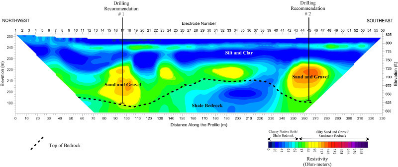
Resistivity Profile for Water Location