
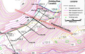
A regional mining company observed an unexplained, continual decrease in the water level of their mine water lake. As the existing dam appeared to be intact, the lead engineer assumed that subterranean karst features within the bedrock were responsible for the seepage and asked Mundell to perform a detailed geophysical survey. After collecting eight 2-D resistivity profiles across the site, all of which showed some level of karst development within the bedrock, we were able to detail the primary flow pathways, and make recommendations to the mine regarding the remediation of the seepage……Read More »
Geophysics Portfolio
Characterizing Karst Geology Beneath Proposed Roadways Using Geophysical Methods (2011)
Herbert, G. J. and Mundell, J. A., “Characterizing Karst Geology Beneath Proposed Roadways Using Geophysical Methods,” in Proceedings of the 62nd Highway Geology Symposium, Lexington, Kentucky, July 25-29, 2011.
The Application of Geophysical Methods to Environmental Investigations (2011)
Mundell, J.A., Byer, B., Howell, M., Vanderlaan, J., and Brumbaugh, R., “The Application of Geophysical Methods to Environmental Investigations,” Indiana Department of Environmental Management’s Consultant’s Day, July 27, 2011.
Use of Geophysical Imaging for Characterizing Subsurface Conditions at Large-scale Geothermal Wellfields (2011)
Mundell, J. A. and Hebert, G., “Use of Geophysical Imaging for Characterizing Subsurface Conditions at Large-scale Geothermal Wellfields,” 32nd Annual Indiana Water Resources Association Conference, Ball State University, June 2, 2011.
Optimization of Ground Water Resources Using Geophysical Methods (2011)
Mundell, J.A., Hebert, G.J., “Optimization of Ground Water Resources Using Geophysical Methods,” Indianapolis Department of Water Technical Advisory Group Meeting, Indianapolis, Indiana, May 18, 2011.