Mundell & Associates, Inc.

Consulting Professionals for the Earth and the Environment

  • Careers
  • Contact
  • Español
call us at (317) 630-9060
110 S. Downey Ave, Indianapolis, IN 46219 | Fax: (317) 630-9065
  •  
  • Company
    • About Us
    • Our Staff
    • Mission and Vision
    • Social Mission
    • Hablamos Español
    • Careers
    • Contact
  • Services
  • Industry Solutions
  • Portfolio
  • News
Discuss your projectall news
You are here: Home / Portfolio / Modeling Analysis of Groundwater Contamination Yields Reliable, Accurate Data

Modeling Analysis of Groundwater Contamination Yields Reliable, Accurate Data

portfolio typeCase Historiespdf iconDownload this as PDFPosted on July 30, 2013

Challenge

A former wood treatment  plant which had been in operation since the late 1940s had discharged contaminated wastewater into multiple, unlined impoundments. The water contained PCP, naphthalene and other organic chemicals used to treat and preserve power poles, fence posts, railroad ties and other wood products. Mundell personnel were asked to assess the impact this operation had on groundwater quality in the surrounding area over an extended period of time.

Action

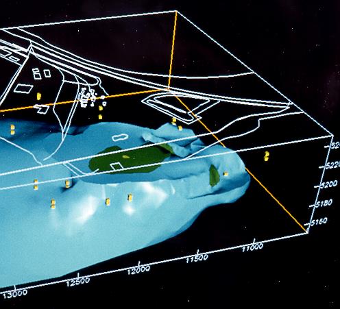
Mundell personnel performed advanced one- and two-dimensional analytical and numerical modeling of the groundwater. Three-dimensional computer visualization analysis was also completed to assess the full extent of vertical and horizontal contamination associated with different past plant site operations. We conducted similar analyses to determine the distribution of other nonaqueous chemicals released from both the plant treatment area and the impoundments.

Results

The calculations and results based on these analyses provided our client with the technical basis to assess whether or not the releases from the wood treatment plant were sudden and accidental results crucial in setting pollution insurance claims.

more information Learn about our related services (Modeling) and industry solutions (Industrial and Auto)

Similar Portfolio Items

  • Groundwater Resource Assessment: Long-Term Sustainability
  • Groundwater Modeling for a Proposed Facility in Indianapolis to Assess the Impact of River Flood Events on the Nearby Groundwater Elevations
  • Advanced Monitoring/Modeling of Surface-Aquifer Interactions of a Levee System and Infrastructure Design Implications

Discuss your projectall news

Portfolio

Case Histories (130)
Presentations (155)
Publications (60)
all news View full portfolio

Latest News

  • John Mundell receives Purdue University’s prestigious Civil Engineering Alumni Achievement Award April 14, 2026
  • Merry Christmas and Happy New Year from Mundell! December 19, 2025
  • John Mundell reflects on the legacy of Pope Francis and his concern for our common home May 27, 2025

Join our mailing list

News

John Mundell receives Purdue University’s prestigious Civil Engineering Alumni Achievement Award

April 14, 2026in Company News

Merry Christmas and Happy New Year from Mundell!

December 19, 2025in Company News

John Mundell reflects on the legacy of Pope Francis and his concern for our common home

May 27, 2025in Community Involvement

Using IndianaMap and web-based GIS to protect drinking water

December 3, 2024in Company News

Our Affiliations

- Midwestern States Environmental Consultants Association
- Environmental & Engineering Geophysical Society
- Professional Geologists of Indiana, Inc.
- National Groundwater Association
- American Societies of Chemical / Civil Engineers
- Association of Environmental and Engineering Geologists
- Indiana Association for Environmental Professionals
- Geological Society of America
- Indiana Geographic Information Council
- Economy of Communion

.....and more more affiliations

Be Inspired

  • Saturday, April 18, 2026
    Free Entrance to National Parks (National Park Opening Weekend)

    National Parks by state

Download calendarGet full calendar ICAL· Google Calendar

Download a Map for Your Next Outdoor Adventure

Reading maps is fun and can tell you a lot about your local environment. The U.S. Geological Survey has been producing detailed topographic maps for more than 125 years. Many are free to download through the USGS Map Store.

Source: Download Maps

.....see all tips more tips

Copyright © 2026 · Mundell & Associates, Inc. · 110 S. Downey Avenue, Indianapolis, IN 46219 · (317) 630-9060 · Privacy Policy · Terms of Use · Sitemap