Mundell & Associates, Inc.

Consulting Professionals for the Earth and the Environment

  • Careers
  • Contact
  • Español
call us at (317) 630-9060
110 S. Downey Ave, Indianapolis, IN 46219 | Fax: (317) 630-9065
  •  
  • Company
    • About Us
    • Our Staff
    • Mission and Vision
    • Social Mission
    • Hablamos Español
    • Careers
    • Contact
  • Services
  • Industry Solutions
  • Portfolio
  • News
Discuss your projectall news
You are here: Home / Portfolio / GPR Survey to Locate Voids and Subsidence Beneath an Industrial Facility Foundation

GPR Survey to Locate Voids and Subsidence Beneath an Industrial Facility Foundation

portfolio typeCase Historiespdf iconDownload this as PDFPosted on August 8, 2013

Challenge

Mundell was contracted by an industrial facility located in central Ohio to scan along an interior storm sewer alignment trending beneath the footprint of the main site building. Recently, evidence had surfaced that the 24-inch storm sewer line in question may be deteriorating, potentially leading to shallow soil loss and washout, as well as the potential for subsidence/void development beneath the Site building foundation in the immediate vicinity of the storm sewer line and trench. Thus, the goal of this project was to map out any such areas, should they be present.

Action

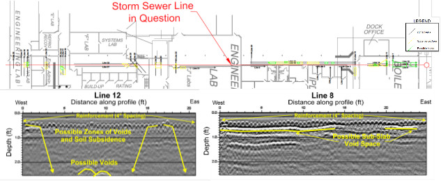
To accomplish the project objectives, Mundell personnel completed a high resolution ground penetrating radar (GPR) survey, utilizing a 1000-megahertz antenna, to view and characterize voids beneath the concrete surface. Given the limited room available for data acquisition along the sewer alignment, a gridded GPR survey proved to be impossible. Instead, GPR data were collected along thirty-eight (38) individual profile lines along the alignment, wherever sufficient room to scan was available.

Results

The GPR results showed evidence of void development along 1/3 of the profiles collected, and evidence of subsidence along ½ of the profiles. It was noted to the client that while surficial interference only permitted imaging of the upper 2 feet of the subsurface, it is likely that the issues detected within the uppermost zone were representative of deeper features of potential concern, closer to the storm sewer itself.

gpr-survey-voids-subsidence-industrial-foundation

more information Learn about our related services (Engineering and Construction) and industry solutions (Industrial and Auto)

Similar Portfolio Items

  • Groundwater Resource Assessment: Long-Term Sustainability
  • Subsurface Imaging of Historic Canal Aqueduct Failure
  • Climate Change and the Public Forum: Communicating Geotechnical Engineering Concepts in a World of Suspicion and Mistrust

Discuss your projectall news

Portfolio

Case Histories (130)
Presentations (155)
Publications (60)
all news View full portfolio

Latest News

  • John Mundell receives Purdue University’s prestigious Civil Engineering Alumni Achievement Award April 14, 2026
  • Merry Christmas and Happy New Year from Mundell! December 19, 2025
  • John Mundell reflects on the legacy of Pope Francis and his concern for our common home May 27, 2025

Join our mailing list

News

John Mundell receives Purdue University’s prestigious Civil Engineering Alumni Achievement Award

April 14, 2026in Company News

Merry Christmas and Happy New Year from Mundell!

December 19, 2025in Company News

John Mundell reflects on the legacy of Pope Francis and his concern for our common home

May 27, 2025in Community Involvement

Using IndianaMap and web-based GIS to protect drinking water

December 3, 2024in Company News

Our Affiliations

- Midwestern States Environmental Consultants Association
- Environmental & Engineering Geophysical Society
- Professional Geologists of Indiana, Inc.
- National Groundwater Association
- American Societies of Chemical / Civil Engineers
- Association of Environmental and Engineering Geologists
- Indiana Association for Environmental Professionals
- Geological Society of America
- Indiana Geographic Information Council
- Economy of Communion

.....and more more affiliations

Be Inspired

  • Saturday, April 18, 2026
    Free Entrance to National Parks (National Park Opening Weekend)

    National Parks by state

Download calendarGet full calendar ICAL· Google Calendar

Download a Map for Your Next Outdoor Adventure

Reading maps is fun and can tell you a lot about your local environment. The U.S. Geological Survey has been producing detailed topographic maps for more than 125 years. Many are free to download through the USGS Map Store.

Source: Download Maps

.....see all tips more tips

Copyright © 2026 · Mundell & Associates, Inc. · 110 S. Downey Avenue, Indianapolis, IN 46219 · (317) 630-9060 · Privacy Policy · Terms of Use · Sitemap