Mundell & Associates, Inc.

Consulting Professionals for the Earth and the Environment

  • Careers
  • Contact
  • Español
call us at (317) 630-9060
110 S. Downey Ave, Indianapolis, IN 46219 | Fax: (317) 630-9065
  •  
  • Company
    • About Us
    • Our Staff
    • Mission and Vision
    • Social Mission
    • Hablamos Español
    • Careers
    • Contact
  • Services
  • Industry Solutions
  • Portfolio
  • News
Discuss your projectall news
You are here: Home / Portfolio / Expert Witness Testimony, Petroleum Storage Facility Litigation

Expert Witness Testimony, Petroleum Storage Facility Litigation

portfolio typeCase Historiespdf iconDownload this as PDFPosted on June 29, 2012

Challenge

Mundell was retained by a major law firm specializing in environmental law, to provide expert witness testimony in various legal proceedings relating to a release of petroleum at a major bulk storage facility in the Midwest. Owners of neighboring properties have alleged that this release has impacted their groundwater and are suing the petroleum company for property damages. As part of the lawsuit, the organization of neighboring property owners has retained a well-known hydrogeologist to construct a groundwater flow model proving that the petroleum release has migrated onto their property.

Action

Mundell reviewed the groundwater model and the resulting conclusions, finding significant flaws in the construction of the model and the interpretation of the actual groundwater flow conditions. The next challenge Mundell faced was being able to effectively communicate relatively complex hydrogeologic concepts to people with little to no geologic background including the litigants, judges, and potential jurors in the case. To this end, Mundell utilized United States Geologic Survey (USGS) topographic maps, aerial photographs, topographic elevation data, and other published geologic information to develop high-quality visual aids using three-dimensional models to depict how groundwater moves through geologic materials in the subsurface.

Results

These visual aids were effective in helping people understand how topography and groundwater elevation maps can be used to interpret groundwater flow direction.

First, an aerial image was introduced to show people how landmarks and property features can be portrayed in map view.

Aerial Image

Then, a topographic map of the area was added to illustrate how the same features can be portrayed on a different kind of map.topographic map

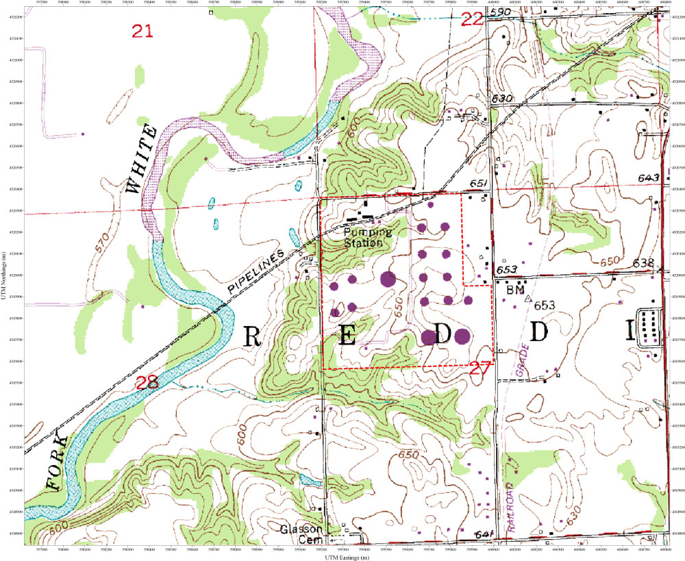
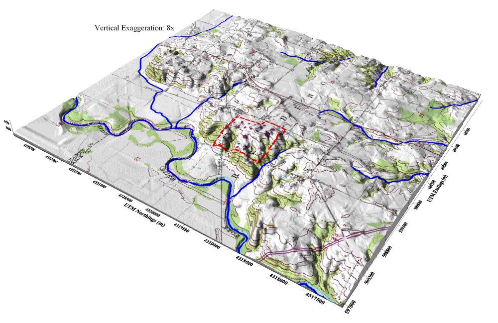
Next, a three-dimensional model of area topography was constructed to show the relationship between topographic contour lines and ground elevation.

3-D Area Topography

Then, a three-dimensional model of the groundwater elevation was constructed to show how contour lines can be used to portray other types of data besides topography. This model was also used to explain the concepts of groundwater divides (orange lines) and high permeability zones (yellow areas).

3D Groundwater Elevation

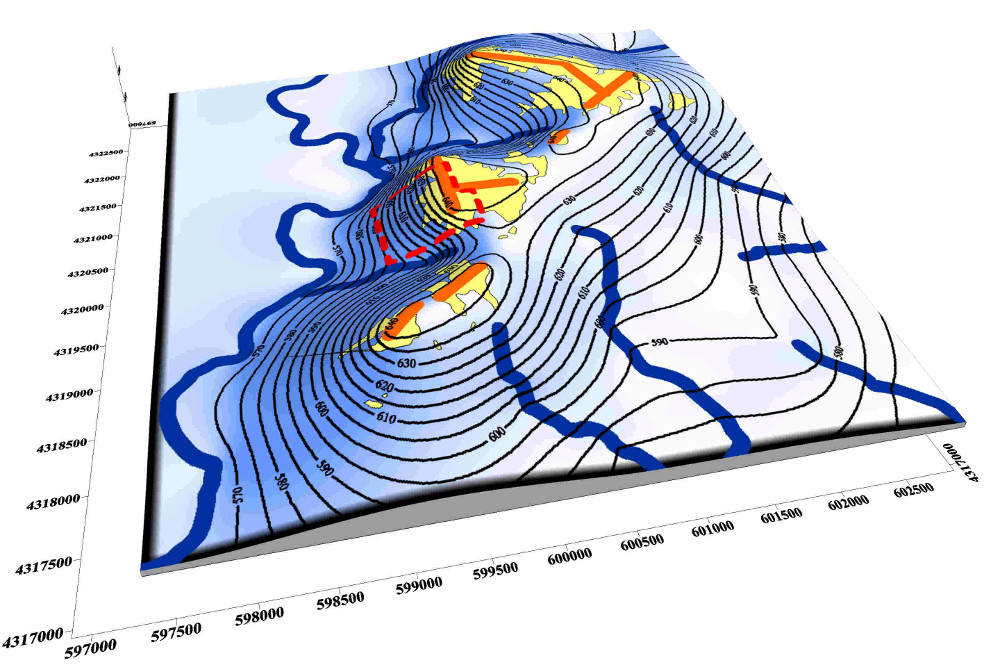
Finally, the data was pulled together and presented on a single map showing actual groundwater flow conditions and highlighting deficiencies in the hydrogeologist’s model.


Combined Groundwater map


more information Learn about our related services (Litigation Support) and industry solutions (Insurance and Law)

Similar Portfolio Items

  • PCB Evaluation and 40 CFR 761.61 Self-directed Cleanup
  • Polynuclear Aromatic Hydrocarbon Distribution – Superfund Site
  • Modeling Provides Confidence In Risk Assessment

Discuss your projectall news

Portfolio

Case Histories (130)
Presentations (155)
Publications (60)
all news View full portfolio

Latest News

  • John Mundell reflects on the legacy of Pope Francis and his concern for our common home May 27, 2025
  • Progress and Challenges for the Future of Indiana Water Resources January 28, 2025
  • Merry Christmas and Happy New Year from Mundell! December 23, 2024

Join our mailing list

News

John Mundell reflects on the legacy of Pope Francis and his concern for our common home

May 27, 2025in Community Involvement

Merry Christmas and Happy New Year from Mundell!

December 23, 2024in Company News

Using IndianaMap and web-based GIS to protect drinking water

December 3, 2024in Company News

Emissions Reporting and Air Dispersion Modeling Allows Tracking of Indy’s Air Pollutants

July 30, 2024in Science and Environment

Our Affiliations

- Midwestern States Environmental Consultants Association
- Environmental & Engineering Geophysical Society
- Professional Geologists of Indiana, Inc.
- National Groundwater Association
- American Societies of Chemical / Civil Engineers
- Association of Environmental and Engineering Geologists
- Indiana Association for Environmental Professionals
- Geological Society of America
- Indiana Geographic Information Council
- Economy of Communion

.....and more more affiliations

Be Inspired

  • Tuesday, December 2, 2025
    EPA established in 1970
Download calendarGet full calendar ICAL· Google Calendar

Giving Tuesday = Giving to Mother Earth

Find a way to give back this week, either to a local environmentally friendly initiative or national charity. Here are some ideas for those in the Indianapolis!

  • Keep Indianapolis Beautiful
  • Hoosier Environmental Council
  • Indiana Serra Club
  • Eco-organizations from Indiana Living Green
  • 21 Environmental Charities You Should Know About
.....see all tips more tips

Copyright © 2025 · Mundell & Associates, Inc. · 110 S. Downey Avenue, Indianapolis, IN 46219 · (317) 630-9060 · Privacy Policy · Terms of Use · Sitemap