Mundell & Associates, Inc.

Consulting Professionals for the Earth and the Environment

  • Careers
  • Hablamos Español
COVID-19 Policies
call us at (317) 630-9060
110 S. Downey Ave, Indianapolis, IN 46219 | Fax: (317) 630-9065
  •  
  • Company
    • About Us
    • Our Staff
    • Mission and Vision
    • Social Mission
    • Hablamos Español
    • Careers
    • Contact
  • Services
  • Industry Solutions
  • Portfolio
  • News
Discuss your projectall news
You are here: Home / Portfolio / Bedrock Fracture Mapping For Site Remediation Project

Bedrock Fracture Mapping For Site Remediation Project

portfolio typeCase Historiespdf iconDownload this as PDFPosted on June 17, 2012

Monitoring Well Locations

Challenge

Mundell completed a highly detailed structural analysis fractured bedrock beneath an active industrial facility near the south coast of Ireland. The chemical methyl tert butyl ether (MTBE) was discovered at the Site in various concentrations in the surface water, shallow groundwater, and groundwater residing within fractured bedrock. Because the subsurface movement of chemicals is controlled by the ease of flow through available subsurface pathways, the primary objective was to evaluate the groundwater flow pathways through the subsurface so that recommendations could be made for a site-wide groundwater monitoring system and remedial strategy.

Action

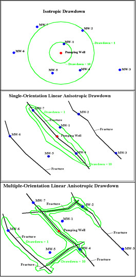
The Site subsurface conditions were complex: a nearly vertically-inclined, highly-fractured, grey mudstone and shale bedrock of lower Carboniferous age buried beneath a varying mantle of human-placed fill, glacial till (boulder clay), and glaciofluvial deposits in low-lying areas within stream valleys. The top of bedrock and significant fracture zones were initially mapped utilizing a combination of two-dimensional resistivity profiling, VLF, and seismic refraction with GRM analysis. However a detailed understanding of the fracture system in the bedrock aquifer was essential to managing and monitoring impacted groundwater at the Site. It was important that monitoring wells be located within fracture zones in order to accurately reflect groundwater impacts to the aquifer. In addition, the production yields and capture zones of groundwater recovery wells will be optimized when located in multiple, inter-connected fracture systems (see illustration to the right).

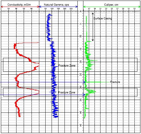
Site-specific information was lacking regarding the nature of the intact rock, detailed lithologic distributions, characteristics of fractures (spacing, orientations, aperture widths, fillings, etc.), and visualization of groundwater flows. Video logging provided an excellent visual record of the physical appearance of the rock, fractures, and in some cases even the real-time groundwater flow dynamics. The color video camera used for this project has the ability to view downwards or to the side. The operator has control of the choice of views, down or side, view rotation speed and direction, and the up or down movement of the camera. The geophysical logging consisted of natural gamma ray, electromagnetic inductive conductivity, and three-arm caliper. These three probes provided information pertaining to lithology (primary gamma), porosity (primarily conductivity), and physical strength of the rock, and thus fracturing by implication (primarily caliper).

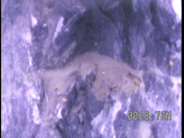
Example interpreted geophysical log with video still frame showing large fracture. Groundwater could be seen flowing into the well through this fracture and depositing the sand seen in the image (light brown material near the center of the photo).

bedrock fracture from borehole camera

Borehole log showing EM conductivity, natural gamma, and caliper measurements

more information Learn about our related services (Geophysics)

Similar Portfolio Items

  • Geophysical Evaluation of Dam Seepage to Support Rehabilitation Efforts
  • The Use of Geophysical Surveys for Enhanced Environmental Characterization in Karst Terranes (2020)
  • Subsurface Imaging of Historic Canal Aqueduct Failure

Discuss your projectall news

all portfolio View entire portfolio

Portfolio Filter

  • Reset All

Text Search

News

Notice about COVID-19 policies

March 24, 2020in Company News

Featured: Mundell conducts environmental sampling in Franklin, Indiana

June 29, 2018in Science and Environment

Christmas Doll Project

January 6, 2021in Community Involvement

Merry Christmas and Happy Holidays from Mundell!

December 23, 2020in Company News

EPA Celebrates 50 Years of Drinking Water Research and Protection

December 2, 2020in Company News

Mundell Completes Environmental Review as Part of a Community Collaboration in Delaware County

November 5, 2020in Science and Environment

Our Affiliations

- Midwestern States Environmental Consultants Association
- Environmental & Engineering Geophysical Society
- Professional Geologists of Indiana, Inc.
- National Ground Water Association
- American Societies of Chemical / Civil Engineers Engineers without Borders
- Association of Environmental and Engineering Geologists
- Indiana Association for Environmental Professionals
- Geological Society of American
- Indiana Circular Economy Initiative
- Economy of Communion
- Indiana Recycling Coalition

.....and more more affiliations

Be Inspired

Loading...
Download calendarGet full calendar ICAL· Google Calendar

Become a “Green Shopper”

Keep reusable bags in your car or near the door so they are easy to grab when you go. You can also shop with the environment in mind. “Green purchasing” means buying smart. Look for products that help conserve natural resources, save energy and prevent waste.

.....see all tips more tips

Copyright © 2021 · Mundell & Associates, Inc. · 110 S. Downey Avenue, Indianapolis, IN 46219 · (317) 630-9060 · Privacy Policy · Terms of Use · Sitemap