Mundell & Associates, Inc.

Consulting Professionals for the Earth and the Environment

  • Careers
  • Contact
  • Español
call us at (317) 630-9060
110 S. Downey Ave, Indianapolis, IN 46219 | Fax: (317) 630-9065
  •  
  • Company
    • About Us
    • Our Staff
    • Mission and Vision
    • Social Mission
    • Hablamos Español
    • Careers
    • Contact
  • Services
  • Industry Solutions
  • Portfolio
  • News
Discuss your projectall news
You are here: Home / Portfolio / Geophysical and Detailed Site Mapping of Cemetery Grounds

Geophysical and Detailed Site Mapping of Cemetery Grounds

portfolio typeCase Historiespdf iconDownload this as PDFPosted on June 22, 2012

EM-61 Metal Detection Map

An EM61 metal detection map (right) indicating presence of potential gravesites.

Challenge

Indiana, like other locations around the world, contains practically innumerable small, privately owned cemeteries, which have relatively long histories, often spanning back to the early days of Indiana statehood in 1816. Mundell was retained by a Cemetery Association to assist them in documenting and accurately marking the existing marked graves (over 450) in one of these cemeteries, using modern surveying techniques, and utilizing geophysical methods for identifying potential unmarked graves, most of which would be presumed to be some of the oldest graves.

Action

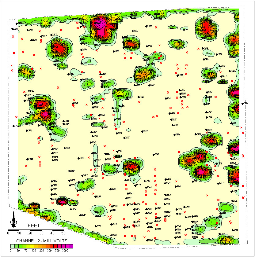
Mundell approached the challenge by combining two geophysical techniques. The first, electromagnetic (EM) mapping, was conducted with two instruments: a Geonics EM-61 metal detector, used to characterize the distribution of buried metallic objects, and a Geonics EM-38 terrain conductivity meter, used primarily to quantify variations in soil conductivity due to disturbances in the soil caused by the excavation and backfilling of graves. The second technique consisted of ground penetrating radar (GPR), utilizing a Sensors & Software Nogginplus SmartCart integrated GPR system. After data collection, a GPR mapping program was used to create GPR amplitude depth slice maps at 1-foot (0.3 meter) intervals.

Results

This approach provided value both in terms of preserving the identity and locations of the graves, as well as offering insight into the locations of some unmarked graves. GPR amplitude mapping appeared to have provided the single greatest insight and level of detail pertaining both to graves containing metallic objects (vaults and caskets) and graves retaining little more than disrupted soil strata and human remains. Conductivity mapping with a high resolution conductivity meter such as a Geonics EM-38 combined with gridded GPR mapping appeared to have the best potential combination of methods for mapping unmarked graves.

Publication

Read more about this project from our publication at SAGEEP 2003.

GPR data confirming potential gravesites

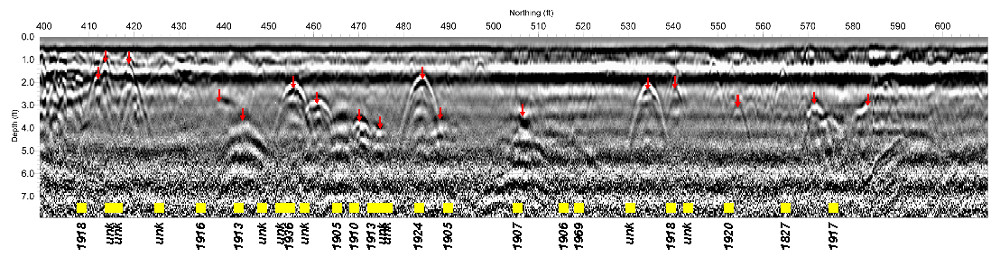
GPR data confirming presences of potential gravesites

more information Learn about our related services (Archaeological Studies)

Similar Portfolio Items

  • Geophysical Mapping of Cultural Resource Area near Pipeline Crossing
  • Use of Geophysical Surveys for Archaeological Excavation Planning
  • Geophysical Imaging in Support of Historic and Cultural Resource Studies for Land Development (2009)

Discuss your projectall news

Portfolio

Case Histories (130)
Presentations (155)
Publications (60)
all news View full portfolio

Latest News

  • Merry Christmas and Happy New Year from Mundell! December 19, 2025
  • John Mundell reflects on the legacy of Pope Francis and his concern for our common home May 27, 2025
  • Progress and Challenges for the Future of Indiana Water Resources January 28, 2025

Join our mailing list

News

Merry Christmas and Happy New Year from Mundell!

December 19, 2025in Company News

John Mundell reflects on the legacy of Pope Francis and his concern for our common home

May 27, 2025in Community Involvement

Using IndianaMap and web-based GIS to protect drinking water

December 3, 2024in Company News

Emissions Reporting and Air Dispersion Modeling Allows Tracking of Indy’s Air Pollutants

July 30, 2024in Science and Environment

Our Affiliations

- Midwestern States Environmental Consultants Association
- Environmental & Engineering Geophysical Society
- Professional Geologists of Indiana, Inc.
- National Groundwater Association
- American Societies of Chemical / Civil Engineers
- Association of Environmental and Engineering Geologists
- Indiana Association for Environmental Professionals
- Geological Society of America
- Indiana Geographic Information Council
- Economy of Communion

.....and more more affiliations

Be Inspired

  • Sunday, March 8, 2026
    National Wildlife Week

    National Wildlife Federation website

Download calendarGet full calendar ICAL· Google Calendar

Check Your Heating Ducts

To ensure that as much warm air as possible is delivered through your central system, check the ductwork and wrap any leaks with duct mastic. Distribution losses (what’s lost while air is transported from your furnace through ductwork to the vents) often amounts to 30%. So, sealing ductwork could increase efficiency and the warm air you receive considerably … keeping you warmer and making your furnace work less.

Source: EPA

.....see all tips more tips

Copyright © 2026 · Mundell & Associates, Inc. · 110 S. Downey Avenue, Indianapolis, IN 46219 · (317) 630-9060 · Privacy Policy · Terms of Use · Sitemap