Mundell & Associates, Inc.

Consulting Professionals for the Earth and the Environment

  • Careers
  • Contact
  • Español
call us at (317) 630-9060
110 S. Downey Ave, Indianapolis, IN 46219 | Fax: (317) 630-9065
  •  
  • Company
    • About Us
    • Our Staff
    • Mission and Vision
    • Social Mission
    • Hablamos Español
    • Careers
    • Contact
  • Services
  • Industry Solutions
  • Portfolio
  • News
Discuss your projectall news
You are here: Home / Portfolio / Utility Mapping at an Active Industrial Facility

Utility Mapping at an Active Industrial Facility

portfolio typeCase Historiespdf iconDownload this as PDFPosted on June 24, 2012

GPR Profile section

A section of Ground Penetrating Radar profile showing the location of rebar and a possible utility at the active industrial facility.

Challenge

Mundell was contacted to map out subfloor utilities and clear over forty (40) proposed soil boring locations at an active automotive production plant in Indianapolis, Indiana, as part of an ongoing sampling program. The majority of the facility was covered with large quantities of machinery as well as reinforced concrete, which made the use of many geophysical techniques impossible.

Action

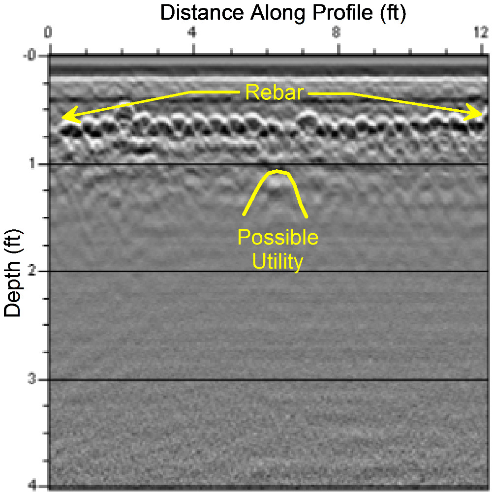
Based on the large number of boring locations and known site features, Mundell selected ground penetrating radar (GPR) mapping to locate utilities across the site. At each proposed soil boring location, a bi-directional, orthogonal, 12 foot by 12 foot grid was established, using the proposed boring location as the center point. GPR profiles were then collected using a Sensors and Software Noggin Plus System equipped with a Smart Cart and shielded 1000 megahertz antennae. All possible utilities detected along each profile line were marked along the ground, with their respective depths noted. Once the grid had been scanned in both directions, a scaled drawing was generated, showing the utility locations relative to the proposed boring location, and allowing for the borings to be moved to the best possible location within the grid.

Result

GPR mapping produced the excellent resolution necessary for the locating of subfloor utilities at an active industrial facility. Not only did this technique allowed for worry-free drilling, but it also increased production, as many boring were able to be moved to areas not containing reinforced concrete, thus negating the need for concrete coring.

more information Learn about our related services (Engineering and Construction) and industry solutions (Industrial and Auto)

Similar Portfolio Items

  • Groundwater Resource Assessment: Long-Term Sustainability
  • Subsurface Imaging of Historic Canal Aqueduct Failure
  • Climate Change and the Public Forum: Communicating Geotechnical Engineering Concepts in a World of Suspicion and Mistrust

Discuss your projectall news

Portfolio

Case Histories (130)
Presentations (155)
Publications (60)
all news View full portfolio

Latest News

  • John Mundell receives Purdue University’s prestigious Civil Engineering Alumni Achievement Award April 14, 2026
  • Merry Christmas and Happy New Year from Mundell! December 19, 2025
  • John Mundell reflects on the legacy of Pope Francis and his concern for our common home May 27, 2025

Join our mailing list

News

John Mundell receives Purdue University’s prestigious Civil Engineering Alumni Achievement Award

April 14, 2026in Company News

Merry Christmas and Happy New Year from Mundell!

December 19, 2025in Company News

John Mundell reflects on the legacy of Pope Francis and his concern for our common home

May 27, 2025in Community Involvement

Using IndianaMap and web-based GIS to protect drinking water

December 3, 2024in Company News

Our Affiliations

- Midwestern States Environmental Consultants Association
- Environmental & Engineering Geophysical Society
- Professional Geologists of Indiana, Inc.
- National Groundwater Association
- American Societies of Chemical / Civil Engineers
- Association of Environmental and Engineering Geologists
- Indiana Association for Environmental Professionals
- Geological Society of America
- Indiana Geographic Information Council
- Economy of Communion

.....and more more affiliations

Be Inspired

  • Saturday, April 18, 2026
    Free Entrance to National Parks (National Park Opening Weekend)

    National Parks by state

Download calendarGet full calendar ICAL· Google Calendar

Download a Map for Your Next Outdoor Adventure

Reading maps is fun and can tell you a lot about your local environment. The U.S. Geological Survey has been producing detailed topographic maps for more than 125 years. Many are free to download through the USGS Map Store.

Source: Download Maps

.....see all tips more tips

Copyright © 2026 · Mundell & Associates, Inc. · 110 S. Downey Avenue, Indianapolis, IN 46219 · (317) 630-9060 · Privacy Policy · Terms of Use · Sitemap