Mundell & Associates, Inc.

Consulting Professionals for the Earth and the Environment

  • Careers
  • Contact
  • Español
call us at (317) 630-9060
110 S. Downey Ave, Indianapolis, IN 46219 | Fax: (317) 630-9065
  •  
  • Company
    • About Us
    • Our Staff
    • Mission and Vision
    • Social Mission
    • Hablamos Español
    • Careers
    • Contact
  • Services
  • Industry Solutions
  • Portfolio
  • News
Discuss your projectall news
You are here: Home / Portfolio / Statewide Aquifer Vulnerability Analysis – Wellhead Areas

Statewide Aquifer Vulnerability Analysis – Wellhead Areas

portfolio typeCase Historiespdf iconDownload this as PDFPosted on June 17, 2012

Aquifer Vulnerability Matrix

Challenge

As part of its wellhead protection program, the Indiana Department of Environmental Management (IDEM) desired to evaluate the ‘aquifer vulnerability’ for wellhead areas within the state of Indiana. This desire was the result of the need to satisfy the requirements of the Source Water Assessment Plan for the State of Indiana, which set as one of its goals, the need for such an evaluation.

Action

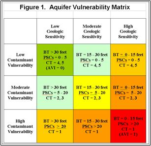
IDEM contracted with Mundell to develop and design an aquifer vulnerability analysis protocol in order to assess the vulnerability to pollutants within the wellhead areas. Mundell developed a protocol based on information already contained in each drinking water supply’s Wellhead Protection Plans (WHPs). First, a detailed geologic and hydrogeologic evaluation (distribution and thickness of the geologic barrier above the supply well screens) was performed for each of the wellhead areas. The potential sources of contamination (PSCs) were then analyzed, both in number and type, in order to calculate an Aquifer Vulnerability Index (AVI) for each of the wellhead areas. The AVI was then evaluated using the Aquifer Vulnerability Matrix. The matrix determines drinking water system susceptibility based on the local geology and the number, proximity and types of PSCs. The system Aquifer Vulnerability was then classified as low, moderate or high based on the system’s final AVI value.

Results

Mundell subsequently determined the AVIs for over eighty (80) wellhead areas as a pilot study, and ranked each water supply according to their relative AVI values. Approximately 5 % of the wellhead areas demonstrated high aquifer vulnerability, and the rest exhibited either moderate or low aquifer vulnerability.

Aquifer Vulnerability Index

more information Learn about our related services (Water Resources) and industry solutions (Municipal)

Similar Portfolio Items

  • Progress and Challenges for the Future of Indiana Water Resources
  • Characterizing Drought to Inform Regional Water Planning in the Central Indiana Region
  • Groundwater Resource Assessment: Long-Term Sustainability

Discuss your projectall news

Portfolio

Case Histories (130)
Presentations (155)
Publications (60)
all news View full portfolio

Latest News

  • John Mundell receives Purdue University’s prestigious Civil Engineering Alumni Achievement Award April 14, 2026
  • Merry Christmas and Happy New Year from Mundell! December 19, 2025
  • John Mundell reflects on the legacy of Pope Francis and his concern for our common home May 27, 2025

Join our mailing list

News

John Mundell receives Purdue University’s prestigious Civil Engineering Alumni Achievement Award

April 14, 2026in Company News

Merry Christmas and Happy New Year from Mundell!

December 19, 2025in Company News

John Mundell reflects on the legacy of Pope Francis and his concern for our common home

May 27, 2025in Community Involvement

Using IndianaMap and web-based GIS to protect drinking water

December 3, 2024in Company News

Our Affiliations

- Midwestern States Environmental Consultants Association
- Environmental & Engineering Geophysical Society
- Professional Geologists of Indiana, Inc.
- National Groundwater Association
- American Societies of Chemical / Civil Engineers
- Association of Environmental and Engineering Geologists
- Indiana Association for Environmental Professionals
- Geological Society of America
- Indiana Geographic Information Council
- Economy of Communion

.....and more more affiliations

Be Inspired

  • Saturday, April 18, 2026
    Free Entrance to National Parks (National Park Opening Weekend)

    National Parks by state

Download calendarGet full calendar ICAL· Google Calendar

Download a Map for Your Next Outdoor Adventure

Reading maps is fun and can tell you a lot about your local environment. The U.S. Geological Survey has been producing detailed topographic maps for more than 125 years. Many are free to download through the USGS Map Store.

Source: Download Maps

.....see all tips more tips

Copyright © 2026 · Mundell & Associates, Inc. · 110 S. Downey Avenue, Indianapolis, IN 46219 · (317) 630-9060 · Privacy Policy · Terms of Use · Sitemap