Mundell & Associates, Inc.

Consulting Professionals for the Earth and the Environment

  • Careers
  • Contact
  • Español
call us at (317) 630-9060
110 S. Downey Ave, Indianapolis, IN 46219 | Fax: (317) 630-9065
  •  
  • Company
    • About Us
    • Our Staff
    • Mission and Vision
    • Social Mission
    • Hablamos Español
    • Careers
    • Contact
  • Services
  • Industry Solutions
  • Portfolio
  • News
Discuss your projectall news
You are here: Home / Portfolio / Map of Voids and Fractures in Limestone Bedrock

Map of Voids and Fractures in Limestone Bedrock

portfolio typeCase Historiespdf iconDownload this as PDFPosted on September 10, 2010

Challenge

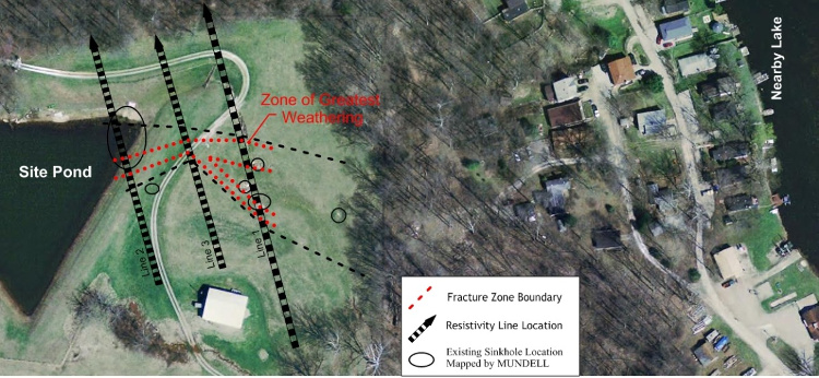
Mundell was hired by a property owner in southern Indiana to identify the locations of potential solution-enhanced features in the limestone bedrock, which may be acting as pathways for water transport from a site pond to a nearby lake. This area, known as the Mitchell Plain, is underlain by Middle Mississippian limestone formations which are very solution-prone. Despite previous attempts to plug visible sinkholes in the area, the water level of the pond had been slowly dropping.

Action

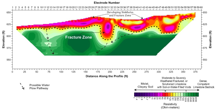
To map out voids and fractures across the site, Mundell utilized electromagnetic conductivity mapping and two-dimensional resistivity profiling to measure the variation in the electrical properties of the upper 100 feet of subsurface. Mundell collected conductivity data across the site (4 acre), and used the data to place three (3) resistivity profile lines in order to further characterize features of interest.

Results

The main feature of interest identified was a large fracture zone, ranging in width from 50 to 150 feet, which can be seen trending east-southeast from the northeastern corner of the pond towards a lake located east of the property. This zone (present on all three resistivity profiles) was likely acting as the primary mode of transport for the pond water to the lake, as well as leading to additional sinkhole development.

Mundell recommended that this feature must be addressed in order to minimize further excessive drainage of the pond by plugging these enhanced flow pathways by implementing a controlled grouting program.


more information Learn about our related services (Water Resources)

Similar Portfolio Items

  • Progress and Challenges for the Future of Indiana Water Resources
  • Characterizing Drought to Inform Regional Water Planning in the Central Indiana Region
  • Groundwater Resource Assessment: Long-Term Sustainability

Discuss your projectall news

Portfolio

Case Histories (130)
Presentations (155)
Publications (60)
all news View full portfolio

Latest News

  • John Mundell reflects on the legacy of Pope Francis and his concern for our common home May 27, 2025
  • Progress and Challenges for the Future of Indiana Water Resources January 28, 2025
  • Merry Christmas and Happy New Year from Mundell! December 23, 2024

Join our mailing list

News

John Mundell reflects on the legacy of Pope Francis and his concern for our common home

May 27, 2025in Community Involvement

Merry Christmas and Happy New Year from Mundell!

December 23, 2024in Company News

Using IndianaMap and web-based GIS to protect drinking water

December 3, 2024in Company News

Emissions Reporting and Air Dispersion Modeling Allows Tracking of Indy’s Air Pollutants

July 30, 2024in Science and Environment

Our Affiliations

- Midwestern States Environmental Consultants Association
- Environmental & Engineering Geophysical Society
- Professional Geologists of Indiana, Inc.
- National Groundwater Association
- American Societies of Chemical / Civil Engineers
- Association of Environmental and Engineering Geologists
- Indiana Association for Environmental Professionals
- Geological Society of America
- Indiana Geographic Information Council
- Economy of Communion

.....and more more affiliations

Be Inspired

  • Monday, June 16, 2025
    National Pollinator Week

    Polinator Partnership website

Download calendarGet full calendar ICAL· Google Calendar

Reduce Erosion and Preserve Topsoil

Land degradation has increased around the world as our human activities pollute or degrade the quality of soil, affecting not only food production but the overall ecosystems. What can we do locally to preserve our soil?

  • Rotate the crops you grow in your garden.
  • Use local mulch, especially in bare stops to help plants ground and prevent water runoff.
  • Plant large plants such as trees and hedges to reduce wind speed.
  • Minimize soil compaction by create permanent walkways and encouraging people to stay on them.
.....see all tips more tips

Copyright © 2025 · Mundell & Associates, Inc. · 110 S. Downey Avenue, Indianapolis, IN 46219 · (317) 630-9060 · Privacy Policy · Terms of Use · Sitemap