Mundell & Associates, Inc.

Consulting Professionals for the Earth and the Environment

  • Careers
  • Contact
  • Español
call us at (317) 630-9060
110 S. Downey Ave, Indianapolis, IN 46219 | Fax: (317) 630-9065
  •  
  • Company
    • About Us
    • Our Staff
    • Mission and Vision
    • Social Mission
    • Hablamos Español
    • Careers
    • Contact
  • Services
  • Industry Solutions
  • Portfolio
  • News
Discuss your projectall news
You are here: Home / Portfolio / Groundwater Modeling for a Proposed Facility in Indianapolis to Assess the Impact of River Flood Events on the Nearby Groundwater Elevations

Groundwater Modeling for a Proposed Facility in Indianapolis to Assess the Impact of River Flood Events on the Nearby Groundwater Elevations

portfolio typeCase Historiespdf iconDownload this as PDFPosted on February 10, 2024

Challenge

The client proposed to build a large facility with the structure below ground surface at a Site directly east of the White River in Indianapolis, IN. Given the proximity to the river, flood events of the river would likely result in a significant rise in groundwater elevation. Mundell was asked to identify the maximum groundwater elevations at the Site during the 50-Year (2-percent-annual-chance) and 100-Year (1-percent-annual-chance) flood events of the White River. To complicate the groundwater assessment, a rock dam (about 10-feet in height) was located along the White River just north of the Site. Furthermore, the results of the assessment were to be used for foundation and/or dewatering design.

Action

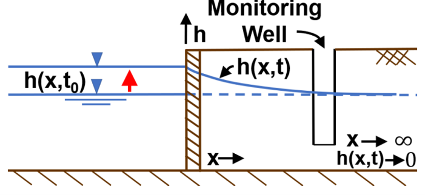
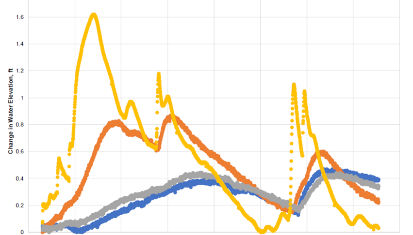
Recognizing the end-use of the groundwater assessment, Mundell used a three-phase modeling approach. Three classes of groundwater flow models were used, including a numerical model (finite difference (MODFLOW), an analytic element model (GFLOW), and a transient stream-aquifer analytical model. The transient stream-aquifer analytical model was developed by Mundell and based on a convolution analytical approach utilizing Python 3 programming language. To implement the transient model, Mundell analyzed the historical White River stage data to predict the expected length of a White River flood event (i.e., determine the time it takes for the river to rise and fall during a flood event). The models were developed to capture the complex stream-aquifer dynamics and to account for the presence of a low-head dam situated upstream of the site. To calibrate and validate the models (i.e., make sure they accurately modeled the conditions at the Site), Mundell used groundwater level transducer data collected in on-Site piezometers and referenced nearby White River stage data.

Results

The models were successfully calibrated and validated using the Site‑specific data. Considering the various modeling results, Mundell delivered the final report which outlined the expected range of groundwater elevations at the Site due to a severe White River flood event. In addition, Mundell provided design recommendations and a detailed description of the modeling process to help the Client understand the results..

more information Learn about our related services (Modeling, Water Resources)

Similar Portfolio Items

  • Progress and Challenges for the Future of Indiana Water Resources
  • Characterizing Drought to Inform Regional Water Planning in the Central Indiana Region
  • Groundwater Resource Assessment: Long-Term Sustainability

Discuss your projectall news

Portfolio

Case Histories (130)
Presentations (155)
Publications (60)
all news View full portfolio

Latest News

  • John Mundell reflects on the legacy of Pope Francis and his concern for our common home May 27, 2025
  • Progress and Challenges for the Future of Indiana Water Resources January 28, 2025
  • Merry Christmas and Happy New Year from Mundell! December 23, 2024

Join our mailing list

News

John Mundell reflects on the legacy of Pope Francis and his concern for our common home

May 27, 2025in Community Involvement

Merry Christmas and Happy New Year from Mundell!

December 23, 2024in Company News

Using IndianaMap and web-based GIS to protect drinking water

December 3, 2024in Company News

Emissions Reporting and Air Dispersion Modeling Allows Tracking of Indy’s Air Pollutants

July 30, 2024in Science and Environment

Our Affiliations

- Midwestern States Environmental Consultants Association
- Environmental & Engineering Geophysical Society
- Professional Geologists of Indiana, Inc.
- National Groundwater Association
- American Societies of Chemical / Civil Engineers
- Association of Environmental and Engineering Geologists
- Indiana Association for Environmental Professionals
- Geological Society of America
- Indiana Geographic Information Council
- Economy of Communion

.....and more more affiliations

Be Inspired

  • Monday, June 16, 2025
    National Pollinator Week

    Polinator Partnership website

Download calendarGet full calendar ICAL· Google Calendar

Reduce Erosion and Preserve Topsoil

Land degradation has increased around the world as our human activities pollute or degrade the quality of soil, affecting not only food production but the overall ecosystems. What can we do locally to preserve our soil?

  • Rotate the crops you grow in your garden.
  • Use local mulch, especially in bare stops to help plants ground and prevent water runoff.
  • Plant large plants such as trees and hedges to reduce wind speed.
  • Minimize soil compaction by create permanent walkways and encouraging people to stay on them.
.....see all tips more tips

Copyright © 2025 · Mundell & Associates, Inc. · 110 S. Downey Avenue, Indianapolis, IN 46219 · (317) 630-9060 · Privacy Policy · Terms of Use · Sitemap