Challenge
Prior to selling three existing, active salt water storage-and-injection facilities, an oil and natural gas company asked Mundell to perform a detailed geophysical survey to delineate the lateral extent of any salt water impacts that may be present on each of the sites, due to faulty tanks, piping, or engineering controls, as part of their pre-sale due diligence.
Action
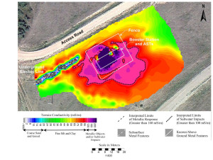
Mundell selected electromagnetic (EM) terrain conductivity mapping using a Geonics EM 31 conductivity meter to delineate the lateral extent of salt water impacts across the site.
Results
In total, Mundell scanned 22 acres of rough terrain across three active saltwater storage and injection facilities, all of which showed some degree of salt water impacts outside of the established secondary containment berms. By establishing a conductivity threshold of 100 millisiemens per meter (mS/m) and denoting that contour interval on the conductivity maps, Mundell was able to approximate the acreage of impacts which would need to be remediated prior to the sale of the properties.


