Mundell & Associates, Inc.

Consulting Professionals for the Earth and the Environment

  • Careers
  • Contact
  • Español
call us at (317) 630-9060
110 S. Downey Ave, Indianapolis, IN 46219 | Fax: (317) 630-9065
  •  
  • Company
    • About Us
    • Our Staff
    • Mission and Vision
    • Social Mission
    • Hablamos Español
    • Careers
    • Contact
  • Services
  • Industry Solutions
  • Portfolio
  • News
Discuss your projectall news
You are here: Home / Portfolio / Bedrock Groundwater Flow Analysis Beneath a Former Industrial Facility

Bedrock Groundwater Flow Analysis Beneath a Former Industrial Facility

portfolio typeCase Historiespdf iconDownload this as PDFPosted on May 7, 2010

Challenge

Mundell was retained by an environmental consultant to conduct an evaluation of groundwater flow conditions in the limestone bedrock beneath a former industrial facility in Sullivan, Missouri. It was believed that a chlorinated solvent spill was being transported in the local bedrock via fracture zones. .Thus, Mundell was asked to detect the localized fracture zones using downhole geophysical methods.

Action

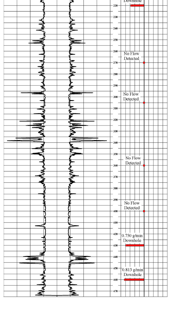
The geophysical testing was conducted in one, six inch diameter borehole, cased from 0 to 205 feet and open from 205 to 475 below ground surface. The downhole logging in the borehole consisted of a three-arm caliper log to measure the diameter of the hole and indicate where the bedrock is weathered and fractured, a video log to visually inspect the bedrock and characteristics of the fractured/weathered intervals, and a heat pulse flow log
to quantify the vertical movement of groundwater under unstressed, ambient flow conditions. The downhole logging was conducted using a portable MGX logging system manufactured by Mount Sopris.

Results

The caliper log (presented with both the original and mirror image to show repeatability) indicates that several fracture zones are present in the bedrock, with the greatest fracturing occurring beneath 300 feet of depth. Video inspection of the hole confirmed the presence of these zones of fracturing/weathering. The flow log indicates that in general, the upper 400 feet of the borehole are under stable flow conditions, and that flow is downward beneath 420 feet, increasing in magnitude towards the bottom of the hole. This is due to an inflow of groundwater from the fractures at that depth interval, which may be transmitting the chlorinated solvent impacts.


more information Learn about our related services (Environmental Applications) and industry solutions (Industrial and Auto)

Similar Portfolio Items

  • Groundwater Resource Assessment: Long-Term Sustainability
  • Multimethod Geophysical Characterization of Fault Systems for Environmental Planning
  • Thermal Source Area Remediation at a Former Industrial Facility

Discuss your projectall news

Portfolio

Case Histories (130)
Presentations (155)
Publications (60)
all news View full portfolio

Latest News

  • John Mundell reflects on the legacy of Pope Francis and his concern for our common home May 27, 2025
  • Progress and Challenges for the Future of Indiana Water Resources January 28, 2025
  • Merry Christmas and Happy New Year from Mundell! December 23, 2024

Join our mailing list

News

John Mundell reflects on the legacy of Pope Francis and his concern for our common home

May 27, 2025in Community Involvement

Merry Christmas and Happy New Year from Mundell!

December 23, 2024in Company News

Using IndianaMap and web-based GIS to protect drinking water

December 3, 2024in Company News

Emissions Reporting and Air Dispersion Modeling Allows Tracking of Indy’s Air Pollutants

July 30, 2024in Science and Environment

Our Affiliations

- Midwestern States Environmental Consultants Association
- Environmental & Engineering Geophysical Society
- Professional Geologists of Indiana, Inc.
- National Groundwater Association
- American Societies of Chemical / Civil Engineers
- Association of Environmental and Engineering Geologists
- Indiana Association for Environmental Professionals
- Geological Society of America
- Indiana Geographic Information Council
- Economy of Communion

.....and more more affiliations

Be Inspired

  • Monday, June 16, 2025
    National Pollinator Week

    Polinator Partnership website

Download calendarGet full calendar ICAL· Google Calendar

Reduce Erosion and Preserve Topsoil

Land degradation has increased around the world as our human activities pollute or degrade the quality of soil, affecting not only food production but the overall ecosystems. What can we do locally to preserve our soil?

  • Rotate the crops you grow in your garden.
  • Use local mulch, especially in bare stops to help plants ground and prevent water runoff.
  • Plant large plants such as trees and hedges to reduce wind speed.
  • Minimize soil compaction by create permanent walkways and encouraging people to stay on them.
.....see all tips more tips

Copyright © 2025 · Mundell & Associates, Inc. · 110 S. Downey Avenue, Indianapolis, IN 46219 · (317) 630-9060 · Privacy Policy · Terms of Use · Sitemap