This article is part of a series on Mundell’s ongoing involvement at the former Amphenol Corporation site in Franklin, Indiana. View a complete list of media links or contact us at (317) 630-9060 to learn more about the project.
In collaboration with the community in Franklin, Indiana, geologists and engineers from Mundell & Associates recently completed two new environmental studies to close data gaps and supplement site investigation and cleanup at the former Amphenol Corporation site.
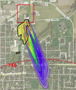
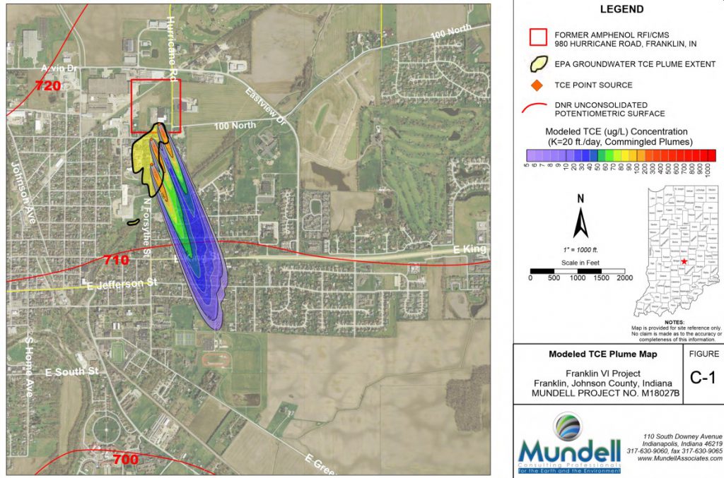
The two studies completed in April 2021 include a geophysical survey to identify preferential flow pathways for further chlorinated volatile organic compounds (CVOCs) impacts near Hurricane Creek, south of the Amphenol site, and a groundwater transport modeling simulation to explore whether the trichloroethylene (TCE) contaminated plume on the site could be spatially more widespread compared to the current plume boundaries officially reported by the U.S. Environmental Protection Agency.
Concerns on this former industrial site date back to the 1980s, and in 2015 a Johnson Country group called If It Was Your Child was formed in response to the alarming rate of childhood cancer in the area. Mundell’s involvement in the project started in 2018 and has since included various environmental investigation activities, such as air sampling, historical document review, and Phase II and Phase III studies. Currently the U.S. EPA is overseeing Amphenol site investigation and cleanup through the federal Resource Conservation and Recovery Act (RCRA) Corrective Action program.
The main purpose of this latest project, conducted by Mundell on behalf of If It Was Your Child, was to map potential existing, yet currently unidentified, migration pathways for the Amphenol groundwater plume that could pose unacceptable risks to the health of residents and the environment.
Results and Recommendations
Geophysical Survey
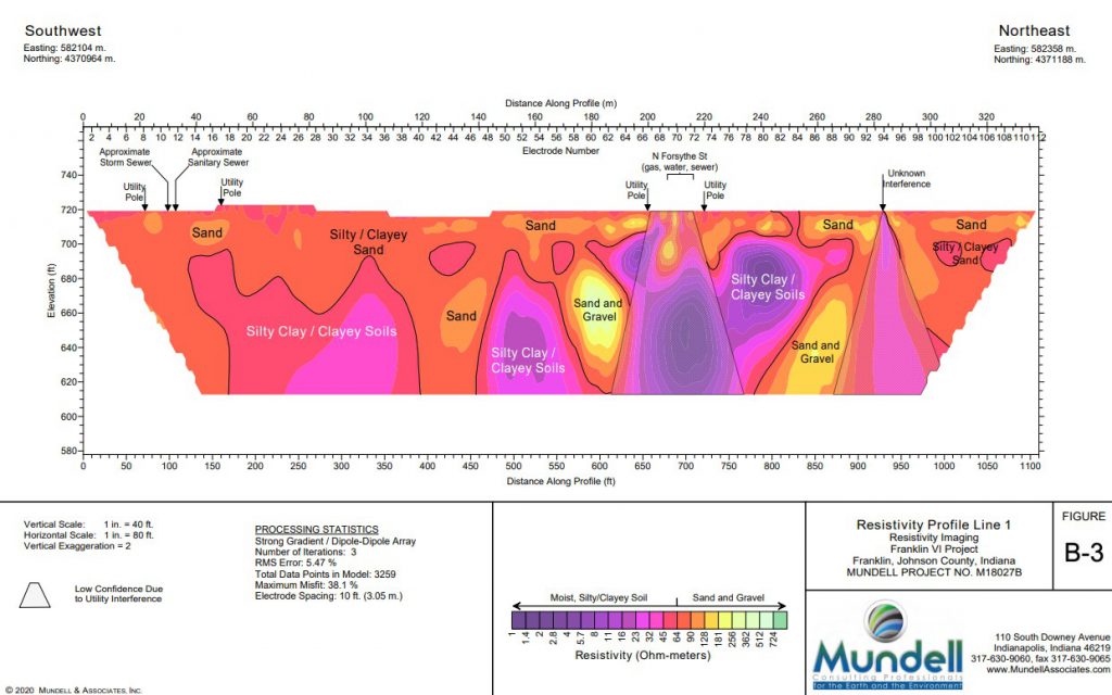
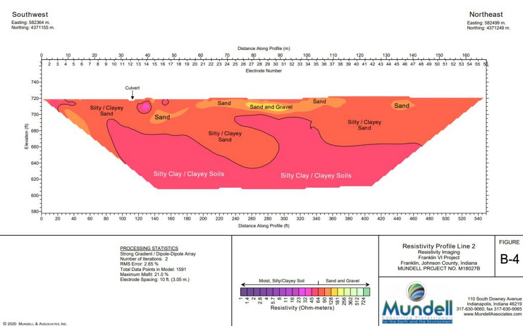
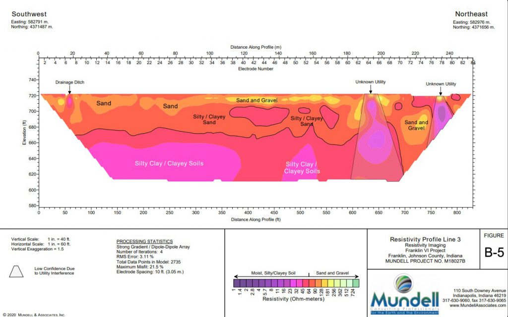
Given the Franklin project area and the desire to characterize coarse-grained deposits that may be controlling groundwater flow and contaminant movement in the general area, two-dimensional electrical resistivity imaging (2-D ERI) was selected as the method of choice for this study.
2-D ERI is just one investigative tool to noninvasively image geologic and hydrogeologic conditions in the subsurface. Data collection of this type can offer more detailed insights of hydrogeologic features over a larger, continuous section of a study area than relying on conventional soil drilling tests (borings).
Based on this 2-D study near Hurricane Creek and further geologic and hydrogeologic review, Mundell determined that unconsolidated aquifer systems south of the Amphenol site near Hurricane Creek indicate the potential for encountering vertically- and horizontally-connected sand and gravel deposits that are highly permeable and vulnerable to contamination. Additionally, the subsurface geophysical profiles indicate interconnected permeable zones which increase the potential for both vertical and horizontal groundwater flow and contaminant migration, thereby increasing the risk of shallow contamination reaching wider and deeper zones.
Future investigation and remediation decisions by the regulatory agencies—including the selection of appropriate locations for the advancement of soil borings and installation of monitoring wells—should be made by incorporating this study’s enhanced understanding of the expected subsurface conditions.
TCE Groundwater Plume Modeling
The question of how far TCE-impacts in groundwater could travel away from historical source-area releases can be resolved by performing additional direct field sampling downgradient of the release areas. However, preliminary modeling of TCE transport in groundwater can predict where these impacts may have traveled prior to completing additional field studies.
The modeling performed by Mundell using the 3-D Domenico-Robbins solution included numerical inputs applied using reasonable hypothetical assumptions of actual aquifer conditions. These inputs are based on currently available site-specific knowledge from sampling data as well as appropriate values from peer-reviewed literature.
The preliminary visual model generated from this method, while not replacing direct field sampling efforts, indicated that the potential exists for a larger, contiguous area of groundwater contamination in Franklin as compared to the area that had initially been sampled.
The results of this initial contaminant modeling exercise are meant to be used to guide the selection of additional groundwater sampling locations for further plume delineation to the south of the currently identified impacted area.
Recommendations
The combined interpretation of the preliminary Hurricane Creek area geophysical survey and groundwater TCE transport model demonstrates clear concerns as to the identified Amphenol plume’s ability to migrate beyond the current study area or impact the surface water and sediment of the Hurricane Creek itself.
More targeted data collection should be completed during the ongoing corrective action requirements including, but not limited to:
- A more comprehensive “Groundwater-Surface Water Interaction/Discharge Study” of Hurricane Creek and underlying aquifer system
- Confirmation that environmental conditions potentially exist for the Amphenol CVOC groundwater plume to have migrated south underneath Hurricane Creek, including initial groundwater vertical profiling and installation of monitoring wells
- Development of an accurate conceptual site model to fully evaluate whether chemical sources that exist in the Franklin, Indiana, community pose additional unacceptable risks to human health and the environment
- An “Area-Wide Hydrogeologic Assessment Report” in collaboration with the Indiana Department of Environmental Management, the U.S. EPA, and the City of Franklin to improve overall understanding of the TCE groundwater plume
These studies completed by Mundell and Associates have provided additional data that inform both the subsurface conditions present and the potential migration pathways and receptor locations that must be incorporated into the any corrective action activities. It is our hope that the Indiana Department of Environmental Management, the U.S. EPA, the City of Franklin, and all environmental consultants involved on this site can work together to obtain accurate data and expedient cleanup for the entire Franklin/Johnson county community.


