Mundell & Associates, Inc.

Consulting Professionals for the Earth and the Environment

  • Careers
  • Contact
  • Español
call us at (317) 630-9060
110 S. Downey Ave, Indianapolis, IN 46219 | Fax: (317) 630-9065
  •  
  • Company
    • About Us
    • Our Staff
    • Mission and Vision
    • Social Mission
    • Hablamos Español
    • Careers
    • Contact
  • Services
  • Industry Solutions
  • Portfolio
  • News
Discuss your projectall news
You are here: Home / Portfolio / Wellfield Exploration for an Ethanol Plant using Deep 2-D Resistivity

Wellfield Exploration for an Ethanol Plant using Deep 2-D Resistivity

portfolio typeCase Historiespdf iconDownload this as PDFPosted on June 24, 2015

Challenge

The high cost of energy and the dependence on foreign oil has recently generated a renewed interest in alternative fuel sources. One of the most promising of these alternative fuel sources is ethanol. Given the proximity to a source of inexpensive corn, many ethanol plants have recently been commissioned in the Midwestern states. However, considering that a 110 million gallons per year ethanol plant can consistently consume up to 1200 gallons of water per minute, the necessity for a good water source is paramount. Mundell was contracted to use geophysical methods to locate potential wellfields for an ethanol plant in central Indiana, within a three square mile area.

Action

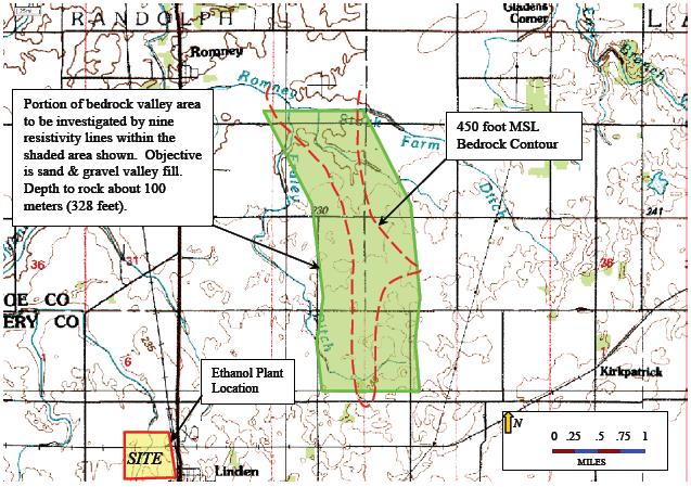
While the geology of the surrounding area is dominated by glacial features, published reports indicate that a minor bedrock valley approximately 1 mile wide, and up to 100 meters deep, trends south-north through the study area (see inset above). This valley is apparently a tributary to the ancient Lafayette (Teays) valley system that lies buried in north central Indiana and runs roughly from east to west. It is believed that alluvial deposits in this tributary valley might provide a productive aquifer. Mundell used two-dimensional electrical resistivity profiling to detect this valley by quantifying the electrical properties of the upper 80 to 120 meters of the subsurface along nine (9) lines of data collection (see inset left). Several of these lines were run end to end, allowing up to one mile of continuous data profiling.

Results

Due to the unusually long length of the lines, the two-dimensional resistivity technique was able to characterize the bedrock valley, as well as the deep alluvium deposits. Drilling of the aquifer bearing material in this area consistently yielded 1000 gallons per minute from a single test well, which was more than sufficient to satisfy the demand of the ethanol plant.

Ethanol Plant Resistivty Summary Map

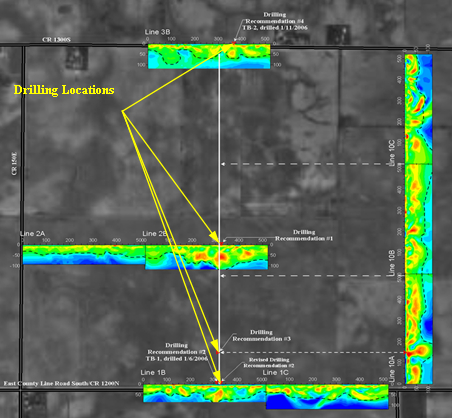
A summary map showing drilling locations for water resources based on 2D electrical resistivity profiles for an ethanol plant

more information Learn about our related services (Water Resources) and industry solutions (Energy)

Similar Portfolio Items

  • Progress and Challenges for the Future of Indiana Water Resources
  • Characterizing Drought to Inform Regional Water Planning in the Central Indiana Region
  • Groundwater Resource Assessment: Long-Term Sustainability

Discuss your projectall news

Portfolio

Case Histories (130)
Presentations (155)
Publications (60)
all news View full portfolio

Latest News

  • John Mundell reflects on the legacy of Pope Francis and his concern for our common home May 27, 2025
  • Progress and Challenges for the Future of Indiana Water Resources January 28, 2025
  • Merry Christmas and Happy New Year from Mundell! December 23, 2024

Join our mailing list

News

John Mundell reflects on the legacy of Pope Francis and his concern for our common home

May 27, 2025in Community Involvement

Merry Christmas and Happy New Year from Mundell!

December 23, 2024in Company News

Using IndianaMap and web-based GIS to protect drinking water

December 3, 2024in Company News

Emissions Reporting and Air Dispersion Modeling Allows Tracking of Indy’s Air Pollutants

July 30, 2024in Science and Environment

Our Affiliations

- Midwestern States Environmental Consultants Association
- Environmental & Engineering Geophysical Society
- Professional Geologists of Indiana, Inc.
- National Groundwater Association
- American Societies of Chemical / Civil Engineers
- Association of Environmental and Engineering Geologists
- Indiana Association for Environmental Professionals
- Geological Society of America
- Indiana Geographic Information Council
- Economy of Communion

.....and more more affiliations

Be Inspired

  • Monday, June 16, 2025
    National Pollinator Week

    Polinator Partnership website

Download calendarGet full calendar ICAL· Google Calendar

Reduce Erosion and Preserve Topsoil

Land degradation has increased around the world as our human activities pollute or degrade the quality of soil, affecting not only food production but the overall ecosystems. What can we do locally to preserve our soil?

  • Rotate the crops you grow in your garden.
  • Use local mulch, especially in bare stops to help plants ground and prevent water runoff.
  • Plant large plants such as trees and hedges to reduce wind speed.
  • Minimize soil compaction by create permanent walkways and encouraging people to stay on them.
.....see all tips more tips

Copyright © 2025 · Mundell & Associates, Inc. · 110 S. Downey Avenue, Indianapolis, IN 46219 · (317) 630-9060 · Privacy Policy · Terms of Use · Sitemap