Challenge
Mundell was contracted to locate potential wellfields for a proposed ethanol plant in northwestern Indiana needing significant (up to 1200 gallons per minute) water supplies within a 590-acre site. In this region, the nominal bedrock depth is about 80 to 100 feet, with the unconsolidated soils above bedrock consisting predominantly of fine-grained glacial till with lesser amounts of complexly interbedded coarse grained sediments. Overall, this is a difficult area geologically to find abundant groundwater yielding formations.
Action
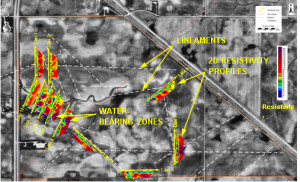
Mundell used both desktop geologic and fracture photo-lineament analysis of the property combined with two-dimwaensional resistivity profiling to determine optimal locations for test drilling. Since lineaments tend to represents zones of potential bedrock fracturing and/or valleys containing coarse valley fill materials, the resistivity profile lines were placed at strategic locations crossing the lineaments.
Results
The eleven resistivity profiles collected across the site (see inset map) detected twenty potential water-bearing zones including eight possible fracture zones and twelve possible zones of sand and gravel. Drilling at these locations produced wells with capacities of up to 800 gallons per minute.


