Mundell & Associates, Inc.

Consulting Professionals for the Earth and the Environment

  • Careers
  • Contact
  • Español
call us at (317) 630-9060
110 S. Downey Ave, Indianapolis, IN 46219 | Fax: (317) 630-9065
  •  
  • Company
    • About Us
    • Our Staff
    • Mission and Vision
    • Social Mission
    • Hablamos Español
    • Careers
    • Contact
  • Services
  • Industry Solutions
  • Portfolio
  • News
Discuss your projectall news
You are here: Home / Portfolio / Subsurface Imaging of Slope Failures

Subsurface Imaging of Slope Failures

portfolio typeCase Historiespdf iconDownload this as PDFPosted on August 7, 2013

Challenge

As a part of a good slope stability study, it is necessary to have a good approximation of thickness of the existing soil/talus (debris) layer overlying the bedrock along the slope. However, this always proves to be a challenge, as most standard drill rigs are incapable of drilling on the said slopes. Recently, Mundell solved this problem by performing a non-destructive and a cost effective geophysical investigation to image beneath several failing slopes along a portion of State Road 66 in southern Indiana.

Action

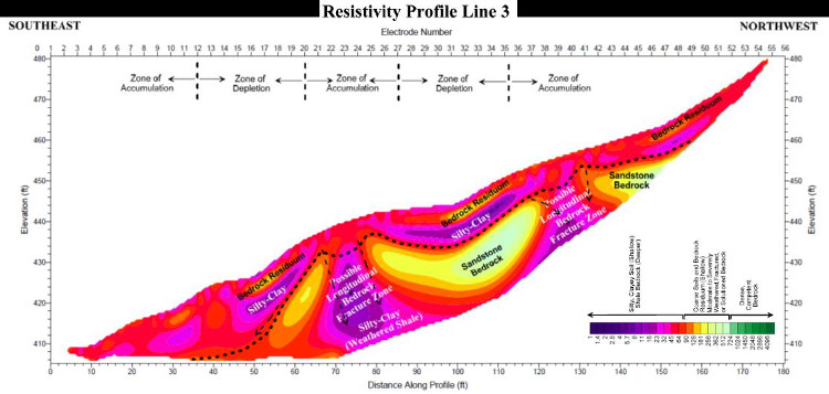
Mundell used the two dimensional electrical resistivity method to image 20 – 30 feet beneath four steep and densely vegetated upslope sections along the roadway. This technique allowed Mundell to not only characterize the thickness of overlying soil/talus, but to also image potential failure zones within the bedrock as well.

Results

The geophysical survey was successful in imaging the unique character of the unconsolidated soil materials overlying bedrock beneath the slope. The variation in the orientation of the soil/bedrock layers beneath the slope helps to illustrate key slope failure features: zones of depletion and accumulation that have likely resulted from multiple past slope movements, as well as potential longitudinal fracture zones. The data proved to be extremely valuable in the road-slope stability design phase.

subsurface-imaging-slope-failure-resistivity

more information Learn about our related services (Engineering and Construction)

Similar Portfolio Items

  • Subsurface Imaging of Historic Canal Aqueduct Failure
  • Climate Change and the Public Forum: Communicating Geotechnical Engineering Concepts in a World of Suspicion and Mistrust
  • Ohio River Levee Seepage and Stability Evaluation Using Geophysical Characterization

Discuss your projectall news

Portfolio

Case Histories (130)
Presentations (155)
Publications (60)
all news View full portfolio

Latest News

  • John Mundell receives Purdue University’s prestigious Civil Engineering Alumni Achievement Award April 14, 2026
  • Merry Christmas and Happy New Year from Mundell! December 19, 2025
  • John Mundell reflects on the legacy of Pope Francis and his concern for our common home May 27, 2025

Join our mailing list

News

John Mundell receives Purdue University’s prestigious Civil Engineering Alumni Achievement Award

April 14, 2026in Company News

Merry Christmas and Happy New Year from Mundell!

December 19, 2025in Company News

John Mundell reflects on the legacy of Pope Francis and his concern for our common home

May 27, 2025in Community Involvement

Using IndianaMap and web-based GIS to protect drinking water

December 3, 2024in Company News

Our Affiliations

- Midwestern States Environmental Consultants Association
- Environmental & Engineering Geophysical Society
- Professional Geologists of Indiana, Inc.
- National Groundwater Association
- American Societies of Chemical / Civil Engineers
- Association of Environmental and Engineering Geologists
- Indiana Association for Environmental Professionals
- Geological Society of America
- Indiana Geographic Information Council
- Economy of Communion

.....and more more affiliations

Be Inspired

  • Saturday, April 18, 2026
    Free Entrance to National Parks (National Park Opening Weekend)

    National Parks by state

Download calendarGet full calendar ICAL· Google Calendar

Download a Map for Your Next Outdoor Adventure

Reading maps is fun and can tell you a lot about your local environment. The U.S. Geological Survey has been producing detailed topographic maps for more than 125 years. Many are free to download through the USGS Map Store.

Source: Download Maps

.....see all tips more tips

Copyright © 2026 · Mundell & Associates, Inc. · 110 S. Downey Avenue, Indianapolis, IN 46219 · (317) 630-9060 · Privacy Policy · Terms of Use · Sitemap