Mundell & Associates, Inc.

Consulting Professionals for the Earth and the Environment

  • Careers
  • Contact
  • Español
call us at (317) 630-9060
110 S. Downey Ave, Indianapolis, IN 46219 | Fax: (317) 630-9065
  •  
  • Company
    • About Us
    • Our Staff
    • Mission and Vision
    • Social Mission
    • Hablamos Español
    • Careers
    • Contact
  • Services
  • Industry Solutions
  • Portfolio
  • News
Discuss your projectall news
You are here: Home / Portfolio / Karst Feature Delineation Prior to Commercial Development

Karst Feature Delineation Prior to Commercial Development

portfolio typeCase Historiespdf iconDownload this as PDFPosted on June 25, 2013

Geophysical Survey Map

EM-34 vertical dipole map overlain with interpreted top of bedrock contours (dark contours) and surface topography (light contours).

Challenge

Construction on top of the solution-prone Burlington-Keokuk Limestone bedrock found in southwestern Missouri always has the potential for karst-related problems. Prior to contacting Mundell, a geotechnical engineer had advanced over sixty (60) soil borings across a proposed retail site located near Republic, Missouri, in an attempt to characterize the subsurface geology. The borings indicated an irregular bedrock surface. These results, along with the known existence of sinkholes across the site, led to the suggestion that a geophysical investigation be conducted to map out any unknown karst features present beneath the site.

Action

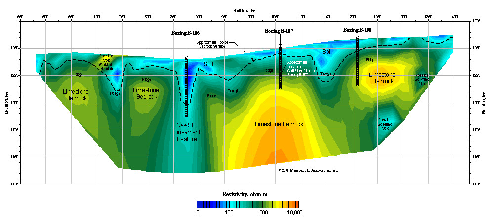
To characterize the bedrock beneath the site and locate any unknown karst features, Mundell selected deep conductivity mapping using a Geonics EM-34 Terrain Conductivity Meter with a 10-meter coil spacing in both the horizontal and vertical dipole modes. This technique provided a map view of the geology beneath the site at both the 7.5 meter and 15 meter depths. Potential karst features detected using this technique were then further characterized using an AGI Sting R1 Resistivity Meter to collect a total of four, vertical, 2 dimentional resistivity profiles designed to provide a cross-sectional view of the karst geology present beneath the site.

Results

In order for better data correlation, the conductivity data were converted into resistivity data (conductivity is the inverse of resistivity). The horizontal dipole map shows the near surface materials (residual soils, fill, and weathered bedrock) as well as the shallowest bedrock, and correlated well with the geotechnical borings. The vertical dipole map emphasizes deeper features within the bedrock, showing where the bedrock is competent, and where it is not. The 2-D resistivity profiles supported the conductivity results, allowing for the karstic features detected beneath the site to be accounted for in the construction design.

karst-feature-delineation-commercial-development-resistivity-profile

2-D Resistivity Profile

more information Learn about our related services (Engineering and Construction)

Similar Portfolio Items

  • Subsurface Imaging of Historic Canal Aqueduct Failure
  • Climate Change and the Public Forum: Communicating Geotechnical Engineering Concepts in a World of Suspicion and Mistrust
  • Ohio River Levee Seepage and Stability Evaluation Using Geophysical Characterization

Discuss your projectall news

Portfolio

Case Histories (130)
Presentations (155)
Publications (60)
all news View full portfolio

Latest News

  • Merry Christmas and Happy New Year from Mundell! December 19, 2025
  • John Mundell reflects on the legacy of Pope Francis and his concern for our common home May 27, 2025
  • Progress and Challenges for the Future of Indiana Water Resources January 28, 2025

Join our mailing list

News

Merry Christmas and Happy New Year from Mundell!

December 19, 2025in Company News

John Mundell reflects on the legacy of Pope Francis and his concern for our common home

May 27, 2025in Community Involvement

Using IndianaMap and web-based GIS to protect drinking water

December 3, 2024in Company News

Emissions Reporting and Air Dispersion Modeling Allows Tracking of Indy’s Air Pollutants

July 30, 2024in Science and Environment

Our Affiliations

- Midwestern States Environmental Consultants Association
- Environmental & Engineering Geophysical Society
- Professional Geologists of Indiana, Inc.
- National Groundwater Association
- American Societies of Chemical / Civil Engineers
- Association of Environmental and Engineering Geologists
- Indiana Association for Environmental Professionals
- Geological Society of America
- Indiana Geographic Information Council
- Economy of Communion

.....and more more affiliations

Be Inspired

  • Sunday, March 8, 2026
    National Wildlife Week

    National Wildlife Federation website

Download calendarGet full calendar ICAL· Google Calendar

Check Your Heating Ducts

To ensure that as much warm air as possible is delivered through your central system, check the ductwork and wrap any leaks with duct mastic. Distribution losses (what’s lost while air is transported from your furnace through ductwork to the vents) often amounts to 30%. So, sealing ductwork could increase efficiency and the warm air you receive considerably … keeping you warmer and making your furnace work less.

Source: EPA

.....see all tips more tips

Copyright © 2026 · Mundell & Associates, Inc. · 110 S. Downey Avenue, Indianapolis, IN 46219 · (317) 630-9060 · Privacy Policy · Terms of Use · Sitemap