Mundell & Associates, Inc.

Consulting Professionals for the Earth and the Environment

  • Careers
  • Contact
  • Español
call us at (317) 630-9060
110 S. Downey Ave, Indianapolis, IN 46219 | Fax: (317) 630-9065
  •  
  • Company
    • About Us
    • Our Staff
    • Mission and Vision
    • Social Mission
    • Hablamos Español
    • Careers
    • Contact
  • Services
  • Industry Solutions
  • Portfolio
  • News
Discuss your projectall news
You are here: Home / Portfolio / Wellfield Exploration for a Town Water Supply

Wellfield Exploration for a Town Water Supply

portfolio typeCase Historiespdf iconDownload this as PDFPosted on June 24, 2015

2D Resistivity

A two dimensional electrical resistivity profile to locate aquifer materials for potential water resource exploration for a town water supply.

Challenge

A growing town in central Indiana had a geologic setting consisting of Mississippian inter-bedded siltstone and shale with discontinuous sandstone and limestone bedrock, overlain by clay-dominated glacial till, a hydrologic condition that is not very favorable to the production of groundwater. Yet with continuing growth, the town needed to increase its water supply. Mundell was contacted to provide geophysical exploration services to increase the likelihood of finding productive aquifer materials for test drilling. The recent drilling of three low-yielding test wells had prompted the desire for the geophysical survey.

Action

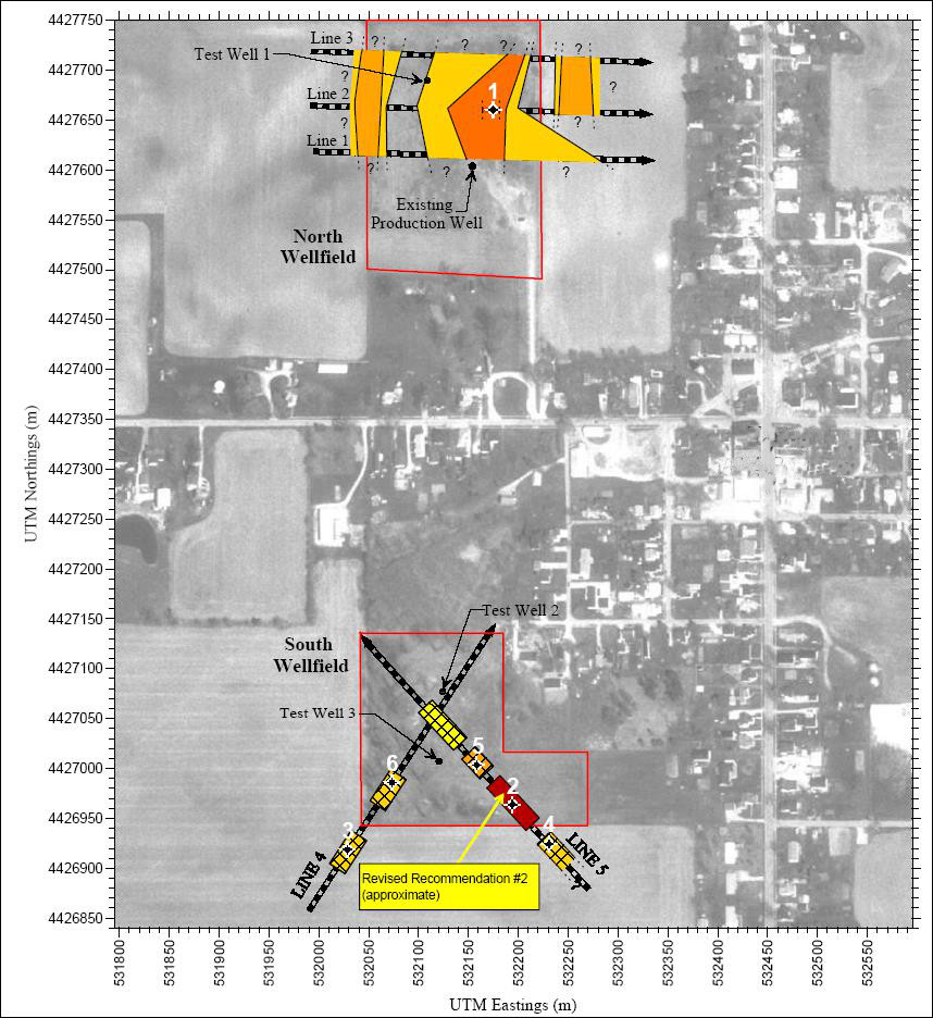
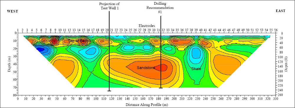
Mundell used 2-dimensional electrical resistivity imaging to quantify the resistivity of the upper 75 meters of the subsurface. An AGI Supersting R8 with 56 electrodes was used to gather dipole-dipole arrays along a total of five (5) resistivity profiles in two areas designated for study, the North and South Wellfields. The geophysical aquifer targets were 1) electrically resistive unconsolidated sand and gravel contained within the glacial drift and 2) resistive sandstone or limestone facies found within predominantly siltstone and shale bedrock. Currently, existing groundwater production is exclusively from sandstone within the bedrock in the North Wellfield.

Results

Several large, high resistivity anomalies were found in the bedrock in the North Wellfield that, based on existing drilling results, correspond to sandstone bodies such as the one shown to the right. Sufficient continuity of the anomalies existed to allow the interpretation of three north-south oriented sand bodies as shown above. The largest body was drilled, yielding several hundred gallons per minute, a result exceeding both prior test wells and client expectations.

Wellfield Exploration

more information Learn about our related services (Water Resources) and industry solutions (Municipal)

Similar Portfolio Items

  • Progress and Challenges for the Future of Indiana Water Resources
  • Characterizing Drought to Inform Regional Water Planning in the Central Indiana Region
  • Groundwater Resource Assessment: Long-Term Sustainability

Discuss your projectall news

Portfolio

Case Histories (130)
Presentations (155)
Publications (60)
all news View full portfolio

Latest News

  • John Mundell reflects on the legacy of Pope Francis and his concern for our common home May 27, 2025
  • Progress and Challenges for the Future of Indiana Water Resources January 28, 2025
  • Merry Christmas and Happy New Year from Mundell! December 23, 2024

Join our mailing list

News

John Mundell reflects on the legacy of Pope Francis and his concern for our common home

May 27, 2025in Community Involvement

Merry Christmas and Happy New Year from Mundell!

December 23, 2024in Company News

Using IndianaMap and web-based GIS to protect drinking water

December 3, 2024in Company News

Emissions Reporting and Air Dispersion Modeling Allows Tracking of Indy’s Air Pollutants

July 30, 2024in Science and Environment

Our Affiliations

- Midwestern States Environmental Consultants Association
- Environmental & Engineering Geophysical Society
- Professional Geologists of Indiana, Inc.
- National Groundwater Association
- American Societies of Chemical / Civil Engineers
- Association of Environmental and Engineering Geologists
- Indiana Association for Environmental Professionals
- Geological Society of America
- Indiana Geographic Information Council
- Economy of Communion

.....and more more affiliations

Be Inspired

  • Monday, June 16, 2025
    National Pollinator Week

    Polinator Partnership website

Download calendarGet full calendar ICAL· Google Calendar

Reduce Erosion and Preserve Topsoil

Land degradation has increased around the world as our human activities pollute or degrade the quality of soil, affecting not only food production but the overall ecosystems. What can we do locally to preserve our soil?

  • Rotate the crops you grow in your garden.
  • Use local mulch, especially in bare stops to help plants ground and prevent water runoff.
  • Plant large plants such as trees and hedges to reduce wind speed.
  • Minimize soil compaction by create permanent walkways and encouraging people to stay on them.
.....see all tips more tips

Copyright © 2025 · Mundell & Associates, Inc. · 110 S. Downey Avenue, Indianapolis, IN 46219 · (317) 630-9060 · Privacy Policy · Terms of Use · Sitemap