Mundell & Associates, Inc.

Consulting Professionals for the Earth and the Environment

  • Careers
  • Contact
  • Español
call us at (317) 630-9060
110 S. Downey Ave, Indianapolis, IN 46219 | Fax: (317) 630-9065
  •  
  • Company
    • About Us
    • Our Staff
    • Mission and Vision
    • Social Mission
    • Hablamos Español
    • Careers
    • Contact
  • Services
  • Industry Solutions
  • Portfolio
  • News
Discuss your projectall news
You are here: Home / Portfolio / Metal Detection Survey of an Urban Area

Metal Detection Survey of an Urban Area

portfolio typeCase Historiespdf iconDownload this as PDFPosted on May 8, 2010

Introduction

Construction work as part of a proposed residential development effort in a major Midwestern city revealed the presence of buried steel drums within a portion of the Site. Given the size of the Site, it was determined that geophysical mapping would be an appropriate means to provide a preliminary, non-intrusive assessment of buried metal accumulations. Based on the Site conditions and project objectives, Mundell performed a metal detection survey using a Geonics EM-61 MKII in conjunction with a Trimble Ag114 Global Positioning System (GPS) receiver for survey control. Using GPS to record the instrument location rather than conventional survey methods allowed for the rapid and cost-effective mapping of the more than 4 acres of accessible Site area.

The EM-61 MKII is a high-sensitivity, high-resolution, time-domain metal detector. It consists of two vertically-separated, coaxial, square coils, each with a dimension of one meter by one meter, mounted to a wheel assembly (see photograph below). During operation of the instrument, the transmitter coil is briefly energized, which creates an electromagnetic field (EMF) that induces a secondary EMF in subsurface materials. The decay characteristic of this secondary EMF is then measured with both coils. The EMF associated with poor conductors decays relatively quickly while the EMF associated with conductive metallic objects decays relatively slowly. The additional measurement afforded by using two coils to measure the EMF decay is utilized to filter out the effect of near-surface metallic materials, allowing for a distinction between deeper and shallower metallic objects.

Conclusions

Figures 1 and 2 illustrate the EM-61 MKII metal detection results as a color contour map of the instrument response (in milliVolts). The Channel Three map (Figure 1) shows both above ground and buried metallic objects, while the Channel Difference Map (Figure 2) predominantly portrays buried metallic objects. Using a standard Mundell color scale, Figures 1 and 2 show large accumulations of metallic objects as red to violet with areas of smaller accumulations depicted as yellow to orange, areas with few or no metallic objects are presented as cross-hatched.

The EM-61 MKII metal detection mapping revealed occurrences of numerous sporadically placed metallic objects placed in a somewhat haphazard pattern. The central portion of the Site contains a laterally extensive collection of surficial metallic objects with a number of locations of buried metallic objects within. The two largest EM61 MKII anomalies across the Site represent significant accumulations of buried metal, and have a somewhat organized appearance often seen with systematic drum burials.

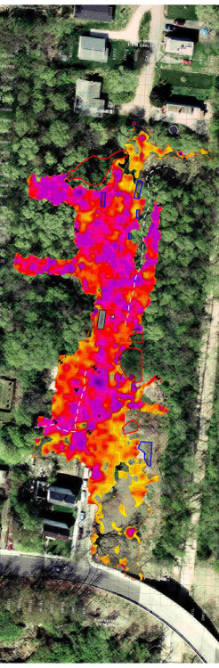
EM-61 MKII Channel Three Map
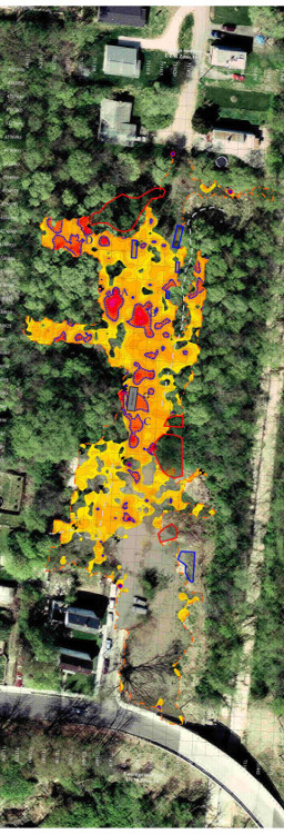
EM-61 MKII Channel Difference Map

more information Learn about our related services (Engineering and Construction) and industry solutions (Municipal)

Similar Portfolio Items

  • Groundwater Flow and Capture Zone Analysis of a Chlorinated Solvent Plume, Pump & Treat System, and nearby Municipal Well
  • Subsurface Imaging of Historic Canal Aqueduct Failure
  • Groundwater Protection Programs of Marion County, Indiana

Discuss your projectall news

Portfolio

Case Histories (130)
Presentations (155)
Publications (60)
all news View full portfolio

Latest News

  • John Mundell reflects on the legacy of Pope Francis and his concern for our common home May 27, 2025
  • Progress and Challenges for the Future of Indiana Water Resources January 28, 2025
  • Merry Christmas and Happy New Year from Mundell! December 23, 2024

Join our mailing list

News

John Mundell reflects on the legacy of Pope Francis and his concern for our common home

May 27, 2025in Community Involvement

Merry Christmas and Happy New Year from Mundell!

December 23, 2024in Company News

Using IndianaMap and web-based GIS to protect drinking water

December 3, 2024in Company News

Emissions Reporting and Air Dispersion Modeling Allows Tracking of Indy’s Air Pollutants

July 30, 2024in Science and Environment

Our Affiliations

- Midwestern States Environmental Consultants Association
- Environmental & Engineering Geophysical Society
- Professional Geologists of Indiana, Inc.
- National Groundwater Association
- American Societies of Chemical / Civil Engineers
- Association of Environmental and Engineering Geologists
- Indiana Association for Environmental Professionals
- Geological Society of America
- Indiana Geographic Information Council
- Economy of Communion

.....and more more affiliations

Be Inspired

  • Tuesday, December 2, 2025
    EPA established in 1970
Download calendarGet full calendar ICAL· Google Calendar

Giving Tuesday = Giving to Mother Earth

Find a way to give back this week, either to a local environmentally friendly initiative or national charity. Here are some ideas for those in the Indianapolis!

  • Keep Indianapolis Beautiful
  • Hoosier Environmental Council
  • Indiana Serra Club
  • Eco-organizations from Indiana Living Green
  • 21 Environmental Charities You Should Know About
.....see all tips more tips

Copyright © 2025 · Mundell & Associates, Inc. · 110 S. Downey Avenue, Indianapolis, IN 46219 · (317) 630-9060 · Privacy Policy · Terms of Use · Sitemap