Mundell & Associates, Inc.

Consulting Professionals for the Earth and the Environment

  • Careers
  • Contact
  • Español
call us at (317) 630-9060
110 S. Downey Ave, Indianapolis, IN 46219 | Fax: (317) 630-9065
  •  
  • Company
    • About Us
    • Our Staff
    • Mission and Vision
    • Social Mission
    • Hablamos Español
    • Careers
    • Contact
  • Services
  • Industry Solutions
  • Portfolio
  • News
Discuss your projectall news
You are here: Home / Portfolio / Geophysical Mapping of Karst Terrane at a Municipal Airport

Geophysical Mapping of Karst Terrane at a Municipal Airport

portfolio typeCase Historiespdf iconDownload this as PDFPosted on November 16, 2015

Terrain conductivity map

Terrain conductivity map showing the contacts between different geologic units.

Challenge

A sinkhole throat was observed during drilling of geotechnical borings as part of a runway expansion project in southern Indiana. The sinkhole throat apparently opened into a void of unknown size so the geotechnical engineering firm sought out Mundell & Associates Geophysics Services to further characterize the entire proposed runway extension area in a rapid and cost-effective manner.

Action

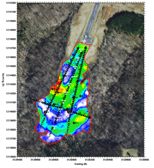
Mundell conducted two-dimensional Electrical Resistivity Imaging (2-D ERI) along four (4) profile lines as well as Frequency-Domain Electromagnetic (FDEM) terrain conductivity mapping. Data collection and density was focused in the area of the proposed runway extension so that the highest depth of penetration could be achieved in the most crucial area. A second phase of data collection involved using a downhole camera imaging system to confirm the presence of the suspected void.

Results

Mundell was able to use a combination of field observations, geologic knowledge, and geophysical measurements to identify several bedrock features of interest and areas of increased fluid flow. Both the terrain conductivity and the 2-D ERI methods were effective in delineating the contacts between geologic units. Potential subsurface voids were identified due to their characteristically low electrical resistivity relative to surrounding, competent bedrock. A soil boring was drilled in the vicinity of the potential void identified by Mundell in its geophysical report and an extensive void was observed with the downhole camera. Observations were communicated directly to the geotechnical engineer on-site and resulted in design modifications to account for the improved understanding of the site conditions.

2-D Electrical Resitivty Profile

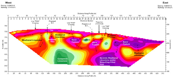
A 2-D ERI profile indicating presence of highly weathered bedrock zones (purple in color) compared to more competent zones (green).

more information Learn about our related services (Engineering and Construction) and industry solutions (Municipal)

Similar Portfolio Items

  • Groundwater Flow and Capture Zone Analysis of a Chlorinated Solvent Plume, Pump & Treat System, and nearby Municipal Well
  • Subsurface Imaging of Historic Canal Aqueduct Failure
  • Groundwater Protection Programs of Marion County, Indiana

Discuss your projectall news

Portfolio

Case Histories (130)
Presentations (155)
Publications (60)
all news View full portfolio

Latest News

  • Progress and Challenges for the Future of Indiana Water Resources January 28, 2025
  • Merry Christmas and Happy New Year from Mundell! December 23, 2024
  • Using IndianaMap and web-based GIS to protect drinking water December 3, 2024

Join our mailing list

News

Merry Christmas and Happy New Year from Mundell!

December 23, 2024in Company News

Using IndianaMap and web-based GIS to protect drinking water

December 3, 2024in Company News

Emissions Reporting and Air Dispersion Modeling Allows Tracking of Indy’s Air Pollutants

July 30, 2024in Science and Environment

Parting the Clouds on Indy’s Air Quality Reputation

July 30, 2024in Science and Environment

Our Affiliations

- Midwestern States Environmental Consultants Association
- Environmental & Engineering Geophysical Society
- Professional Geologists of Indiana, Inc.
- National Groundwater Association
- American Societies of Chemical / Civil Engineers
- Association of Environmental and Engineering Geologists
- Indiana Association for Environmental Professionals
- Geological Society of America
- Indiana Geographic Information Council
- Economy of Communion

.....and more more affiliations

Be Inspired

  • Monday, May 19, 2025
    National Public Works Week

    American Public Works Assocation website

Download calendarGet full calendar ICAL· Google Calendar

Celebrate Biodiversity

Approximately 33% of the food consumed by humans is dependent, either directly or indirectly, on honey bee pollination. Here are a few steps you can take to help these important pollinators!

  • Keep beekeeping in your area viable by buying local honey.
  • Grow a variety of flowering plants in your garden and avoid using pesticides.
  • Learn the difference between honeybees and other flying insects such as wasps/yellow jackets to prevent the inadvertent use of deadly sprays.

Source: Convention on Biological Diversity

.....see all tips more tips

Copyright © 2025 · Mundell & Associates, Inc. · 110 S. Downey Avenue, Indianapolis, IN 46219 · (317) 630-9060 · Privacy Policy · Terms of Use · Sitemap