Mundell & Associates, Inc.

Consulting Professionals for the Earth and the Environment

  • Careers
  • Hablamos Español
call us at (317) 630-9060
110 S. Downey Ave, Indianapolis, IN 46219 | Fax: (317) 630-9065
  •  
  • Company
    • About Us
    • Our Staff
    • Mission and Vision
    • Social Mission
    • Hablamos Español
    • Careers
    • Contact
  • Services
  • Industry Solutions
  • Portfolio
  • News
Discuss your projectall news
You are here: Home / Portfolio / Irrigation Well Exploration Using Geophysical Methods

Irrigation Well Exploration Using Geophysical Methods

portfolio typeCase Historiespdf iconDownload this as PDFPosted on August 8, 2013

Challenge

Successfully placing irrigation wells on large properties without spending tens of thousands of dollars in drilling costs can be a challenging task, especially in portions of the country characterized by silty/clayey soils. Recently, Mundell was approached with a task to locate the best potential water bearing zones across a ~325 acre agricultural property in northern Indiana.

Action

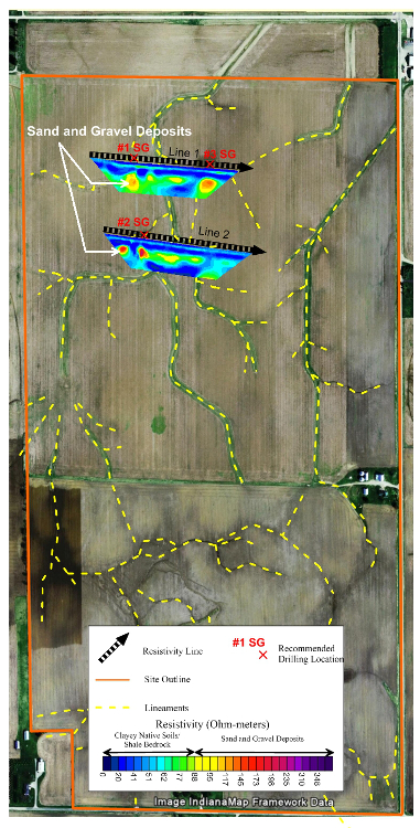
An initial desktop study consisting of a published records search for local geologic/hydrogeologic information and adjacent water well logs was conducted for the property, as was a photo-lineament analysis. This preliminary desktop study helped to pinpoint the portions of the site that were most likely to contain water bearing units. The best potential drilling targets were then further examined using 2-D electrical resistivity imaging. Two resistivity profiles were collected to characterize the upper 200 feet of subsurface.

Results

The two (2) resistivity profiles collected indicated the presence of several channels of water bearing sand and gravel located within the surrounding clayey soils. Preliminary pumping tests within these channels yielded more than 700 gallons of water per minute.

more information Learn about our related services (Water Resources) and industry solutions (Agriculture)

Similar Portfolio Items

  • Advanced Monitoring/Modeling of Surface-Aquifer Interactions of a Levee System and Infrastructure Design Implications
  • Innovative Groundwater Protection Programs of Marion County, Indiana
  • Groundwater Protection Programs in Marion County, Indiana

Discuss your projectall news

all portfolio View entire portfolio

Portfolio Filter

  • Reset All

Text Search

News

Phase II Environmental Testing Completed through a Collaborative Effort between Delaware County and Local Citizens

April 3, 2023in Science and Environment

Regional Levee Project Presented at AEG Annual Meeting during Dams and Levees Symposium

October 7, 2022in Company News

New IDEM Recycling and Waste Diversion Grants Announced

July 8, 2022in Company News

Karst, Cake, and Indiana Geology

April 22, 2022in Science and Environment

Our Affiliations

- Midwestern States Environmental Consultants Association
- Environmental & Engineering Geophysical Society
- Professional Geologists of Indiana, Inc.
- National Ground Water Association
- American Societies of Chemical / Civil Engineers Engineers without Borders
- Association of Environmental and Engineering Geologists
- Indiana Association for Environmental Professionals
- Geological Society of American
- Indiana Circular Economy Initiative
- Economy of Communion
- Indiana Recycling Coalition

.....and more more affiliations

Be Inspired

Loading...
Download calendarGet full calendar ICAL· Google Calendar

Consume with Care

Discover an alternative to using traditional wrapping paper for birthday gifts – like scarves, old newspapers or discarded maps or magazines.

Vanish energy vampires— appliances that suck energy even when not being used – by unplugging them or using power strips.

Source: UNEP

.....see all tips more tips

Copyright © 2023 · Mundell & Associates, Inc. · 110 S. Downey Avenue, Indianapolis, IN 46219 · (317) 630-9060 · Privacy Policy · Terms of Use · Sitemap