Challenge
To determine the need for a new centralized water supply for the Town of Greens Fork, Indiana, Mundell was asked to perform a preliminary hydrogeologic analysis of the potential contaminant release pathways from two existing facilities of concern near the town: an abandoned landfill located to the west of town, and a veal packaging plant located to the east of the town. The results of this evaluation would be used to evaluate the need to replace the residential wells used by individual citizens by a more centralized public water supply.
Action
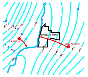
Mundell performed an evaluation of the geologic setting of the town by reviewing published geological reports and Indiana Department of Natural Resources drinking water well logs in the vicinity of the town. To provide a preliminary estimate of the potential contaminant release trajectories from the two facilities of interest, Mundell then constructed an estimated groundwater surface (potentiometric) map within the upper aquifer system near Greens Fork. Since upper aquifer groundwater levels and flow directions are related to water level elevations of area surface water expressions, Mundell digitized the general hydrography in the area including the Greens Fork River and its related tributaries from the U.S. Geological Survey’s quadrangle map. Once the hydrography was digitized, Mundell used the software SURFER to generate the potentiometric surface, from which groundwater flow velocities and flow directions were evaluated.
Results
The results of the analysis indicated that groundwater in the vicinity of the town of Greens Fork flows toward the nearby Greens Fork River, situated within a sand and gravel outwash aquifer system. As such, groundwater from the abandoned landfill flows to the east-southeast and empties into the Greens Fork River about 1,500 ft southwest of Greens Fork. This facility is unlikely to present a direct threat to the groundwater quality in residential wells located in Greens Fork. However, the groundwater beneath the veal packaging plant flows to the west-northwest toward and through the town of Greens Fork and, as such, represents a potential source of upgradient contamination for the town. This information was used by the engineering design firm to present the need for a public water supply system.


