Challenge
Mundell was engaged on behalf of a small municipality in western Indiana to use geophysics to investigate potential areas of interest for expanding the town’s groundwater supply. Water needs for the Town are currently supplied by two municipal production wells, both installed to a depth of 96 feet and located in close proximity to each other.
Three areas of the Town were chosen for study, each selected for having a good possibility of Town access should they be productive. The area of the existing Town wells was also examined to determine the nature of the aquifer there.
The primary drinking water aquifers in the area are the buried sand gravel aquifers, surficial sand and gravel aquifers, and bedrock aquifers. The unconsolidated aquifers in this basin consist of surficial and buried sand and gravel that originated as outwash and alluvial valley fill and typically are found in both recent and relict river valleys. The two existing town wells are located in the same buried sand and gravel aquifer.
Action
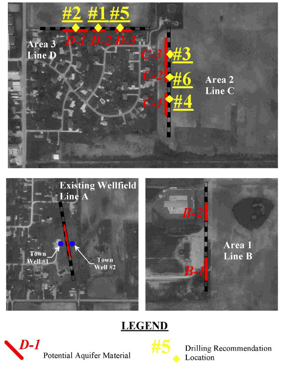
The primary purpose of this geophysical survey was to conduct non-intrusive exploration to evaluate potential locations where an increased likelihood exists of finding adequate high quality sand and gravel for development as a drinking water supply. The general approach that Mundell chose to take on this project was to quantify the electrical properties of the upper 120 to 160 feet of the subsurface along the four lines of geophysical data collection shown on Figure 1. In fresh water environments there is a well-established relationship between the sediment type and electrical resistivity. Coarse-grained sediments (i.e., sand and gravel aquifers) are relatively electrically resistive while fine-grained sediments (i.e., clay and silt) are more conductive. The geophysical study Mundell conducted consisted of the direct measurements of apparent electrical resistivity in a profile-type data set, which is then used to calculate a two-dimensional model of the actual resistivities of the subsurface materials (see example below).
Results
The town wells #1 and #2 are located in the center of a high resistivity mass, which likely represents an area of unconsolidated deposits containing sand and gravel. Similar high resistivity materials are found in Areas 2 and 3. The locations of these were recommended for further exploration with test well drilling. Area 1 also contains high resistivity materials, however not as large in size nor as high in resistivity as the materials found at the existing wellfield, therefore it is unlikely that these areas represent a source of water for the town. Test well drilling was not recommended in Area 1.
In all, six locations were recommended for drilling test wells, they were ranked in the order of their considered potential as viable sources of water for the town, with the most recommended location given a ranking of one (#1) and the least recommended location given a ranking of six (#6).


