
Mundell & Associates

Consulting Professionals for the Earth and the Environment

  • Careers
  • Contact
  • Español
call us at (317) 630-9060
110 S. Downey Ave, Indianapolis, IN 46219 | Fax: (317) 630-9065
  •  
  • Company
    • About Us
    • Our Staff
    • Mission and Vision
    • Social Mission
    • Hablamos Español
    • Careers
    • Contact
  • Services
  • Industry Solutions
  • Portfolio
  • News
Discuss your projectall news
You are here: Home / Portfolio / Quantification of Aggregate Resources Using Geophysics

Quantification of Aggregate Resources Using Geophysics

portfolio typeCase Historiespdf iconDownload this as PDFPosted on May 18, 2012

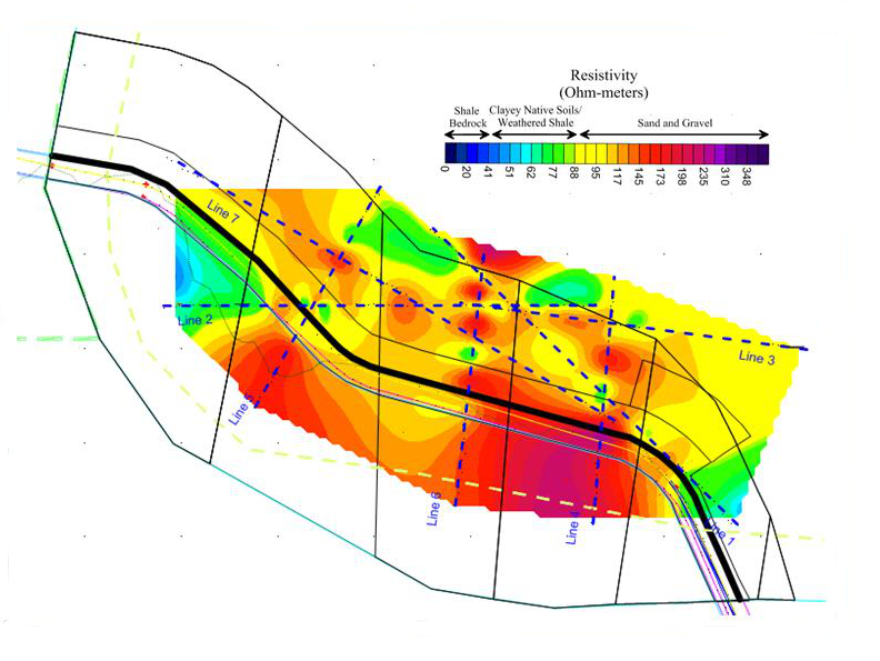
Electrical Resistivity Map

An electrical resistivity a slice map showing lateral variation in electrical resistivity across the site. Higher resistivity values generally equate to larger grain sizes.

Challenge

Mundell was contracted to quantify the extent of the sand and gravel reserves located beneath an 18 acre site in central Indiana. In this region, the nominal bedrock depth is about 90 to 100 feet, with the unconsolidated soils above bedrock consisting predominantly of fine-grained glacial till with high amounts of interbedded coarse grained sediments. However, as a stream bordered the site, sand and gravel resources were expected.

Action

Prior to the geophysical study, four (4) test borings had been advanced across the site. These borings indicated a great deal of variability in the thicknesses of the aggregate across the site. To better understand this variability, and to better delineate the aggregate resources commercially available at the site, Mundell collected seven (7) two-dimensional resistivity profiles to image the upper 100 to 200 feet of the subsurface. These profiles were analyzed for the presence of aggregates, and then studied from a mining perspective, to determine which of the detected resources were minable. Next, the data were compiled into a three-dimensional data set, and slices were taken at elevations where the sand and gravel were most prominent. These slices allowed for a lateral approximation of the aggregates to be made, and then a volume approximated, using estimated thicknesses and standard slope values. After the data was processed, three (3) test borings were advanced along different points of the profile lines by Mundell in order to corroborate the results.

Results

The seven resistivity profiles collected across the site indicated not only great areas of aggregate resources, but allowed for the identification of interbedded clay lenses that reduce the commercial value of the property from the mining perspective. This information, collected in only two days of field work, allowed the client to evaluate the real commercial value of the property.

more information Learn about our related services (Natural Resources)

Similar Portfolio Items

  • Geoscience in the Classroom
  • Geophysical Exploration in Water Resources Assessment (Well Drillers Workshop)
  • Geophysical Exploration in Water Resources Assessment

Discuss your projectall news

Portfolio

Case Histories (130)
Presentations (155)
Publications (60)
all news View full portfolio

Latest News

  • Mundell Supports One Water Indiana Initiative October 6, 2026
  • Mundell Takes Part in Annual Summit September 30, 2026
  • John Mundell receives Purdue University’s prestigious Civil Engineering Alumni Achievement Award April 14, 2026

Join our mailing list

News

Mundell Supports One Water Indiana Initiative

October 6, 2026in Company News

Mundell Takes Part in Annual Summit

September 30, 2026in Company News

John Mundell receives Purdue University’s prestigious Civil Engineering Alumni Achievement Award

April 14, 2026in Company News

Merry Christmas and Happy New Year from Mundell!

December 19, 2025in Company News

Our Affiliations

- Midwestern States Environmental Consultants Association
- Environmental & Engineering Geophysical Society
- Professional Geologists of Indiana, Inc.
- National Groundwater Association
- American Societies of Chemical / Civil Engineers
- Association of Environmental and Engineering Geologists
- Indiana Association for Environmental Professionals
- Geological Society of America
- Indiana Geographic Information Council
- Economy of Communion

.....and more more affiliations

Be Inspired

  • Tuesday, October 6, 2026
    World Habitat Day

    World Habitat Day website

Download calendarGet full calendar ICAL· Google Calendar

Build a Positive Connection with the Earth

  • Buy local products
  • Plant a tree or flowers in your neighborhood
  • Don’t throw trash in public places
  • Calculate your carbon footprint
.....see all tips more tips

Copyright © 2026 · Mundell & Associates, Inc. · 110 S. Downey Avenue, Indianapolis, IN 46219 · (317) 630-9060 · Privacy Policy · Terms of Use · Sitemap