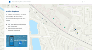
Mundell’s work with the Marion County Wellfield Education Corporation and drinking water protection activities was recently highlighted by the state’s Indiana Geographic Information Office as an exemplary project of IndianaMap data use.
For many years drinking water providers had to use static data or gather it electronically from many different data sources in an effort to understand current and historical potential drinking water contaminants. At the same time, geospatial software was expensive with complicated sharing workflows. Fast forward to several years ago when the new IndianaMap platform was released at the state level to gather data from stewards across the state.
Using data from the Indiana Department of Environmental Management and the Indiana Department of Natural Resources, to name a few, Mundell developed several software workflows and an application for the city of Indianapolis’ drinking water providers to have this real-time data at their fingertips for their particular area of interest.
Because enterprise GIS systems are not needed in this use case, drinking water providers of any size across Indiana can use IndianaMap and the free tools provided to set up similar systems. Mundell can also provide set up services to get organizations or community groups of any size set up and using IndianaMap’s applications and data. Contact us to learn more.


